

Anthony Lomax @ALomax@qoto.org
#Earthquake happenings+tidbits, maps, #MachineLearning... I'm ALomax Scientific: earthquake monitoring and analysis.
"seismicity is only the edges and shadows of complex, 3D space-time tectonic processes"
Car free for daily life since 1976.
Joined Nov 2022
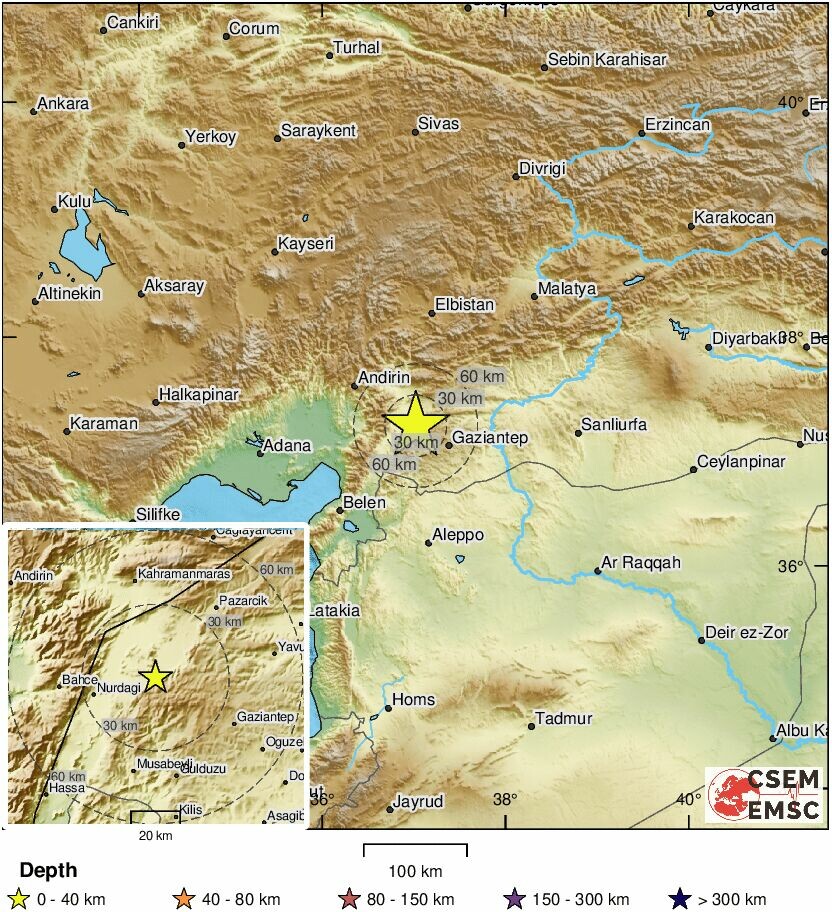
Large earthqueke Turkey, Syria
M7.8 #earthquake #Turkey #Syria
The distance between the two blue markers in this map is ~330km. Some events to the SW could be on separate faults, events further to the NE may be triggered (???) or around the end of a (very long) main rupture (???). http://udim.koeri.boun.edu.tr/zeqmap/hgmmapen.asp
Anthony Lomax
boosted

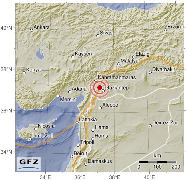
Strong destructive #earthquake in SE Turkey / N Syria, magnitude Mw~7.8.
Mechanism compatible with left-lateral strike-slip on the southern part of East Anatolian Fault system. Aftershock zone extends for ~250km along that fault system. Complex source time function may suggest rupture on several fault branches. The left-lateral East Anatolian Fault system bounds the Anatolian tectonic microplate to the east.
Sources of maps:
• http://geoscope.ipgp.fr/index.php/en/catalog/earthquake-description?seis=us6000jllz
• https://www.emsc-csem.org/Earthquake/earthquake.php?id=1218444#summary
• http://www.koeri.boun.edu.tr/new/en
Large Earthquake
Anthony Lomax
boosted

🔔#Earthquake (#deprem) M7.5 occurred 28 km NW of #Doğanca (#Turkey) 40 min ago (local time 04:17:35). More info at:
📱https://www.emsc-csem.org/service/application/
🌐https://m.emsc.eu/?id=1218444
🖥https://www.emsc-csem.org/Earthquake/earthquake.php?id=1218444
Anthony Lomax
boosted

M 7.5, Turkey
2023-02-06 01:17:35 37.23 37.12 10 km A
http://geofon.gfz-potsdam.de/eqinfo/event.php?from=rss&id=gfz2023cnwr
Anthony Lomax
boosted
I asked #openai #GPT-3 #AI #LLM to write something about the #orogeny in the #Andes.
Well written, but verbose and without much meaning. It basically repeats the prompt's ideas introducing some new details. However it's not enough to say that something is important, you have to explain why. A student giving such an answer will get a bad mark.
I'm not surprised as there is no intention, no understanding by the AI. But such a text can impress / convince a naive person on the subject, and even perhaps even some decision-makers and managers of science.
Anthony Lomax
boosted
Open letter to the #AGU
to support Rose Abramoff @ultracricket
and Peter Kalmus @ClimateHuman
"We as scientists cannot and must not tolerate this censorship and chilling lack of support from our scientific society and therefore urge AGU to, etc…"
Read and sign here https://www.aguopenletter.com/
Anthony Lomax
boosted

So psyched to have been interviewed for this Wired Magazine article about the benefits of solar power canopies in parking lots. Definitely feels like a career milestone to be mentioned in Wired... Its always funny to see what parts of a long interview end up being included in a story, but overall I'm happy with the quotes they used. #solar #energy #climate #energytransition #der https://www.wired.com/story/france-solar-panels-parking-lots/
Anthony Lomax
boosted
Speaking in Davos, the UN secretary general, António Guterres, accused big oil companies of peddling 'the big lie', calling for them to be held accountable.
“Today fossil fuel producers and their enablers are still racing to expand production knowing full well that this business model is inconsistent with human survival”
Anthony Lomax
boosted

Anthony Lomax
boosted
Magnitude Mw~7 #earthquake north of #Halmahera (#Maluku island, Indonesia) in a complex tectonic setting where several micro-plates interact. Quite large discrepancy btw depth estimates (16-46km), complicated source time function. Mechanism is mainly strike-slip.
Source of maps and MT solutions:
https://emsc-csem.org/Earthquake/earthquake.php?id=1211853#
and
http://geoscope.ipgp.fr/index.php/fr/catalogue/description-d-un-seisme?seis=us7000j553
Anthony Lomax
boosted

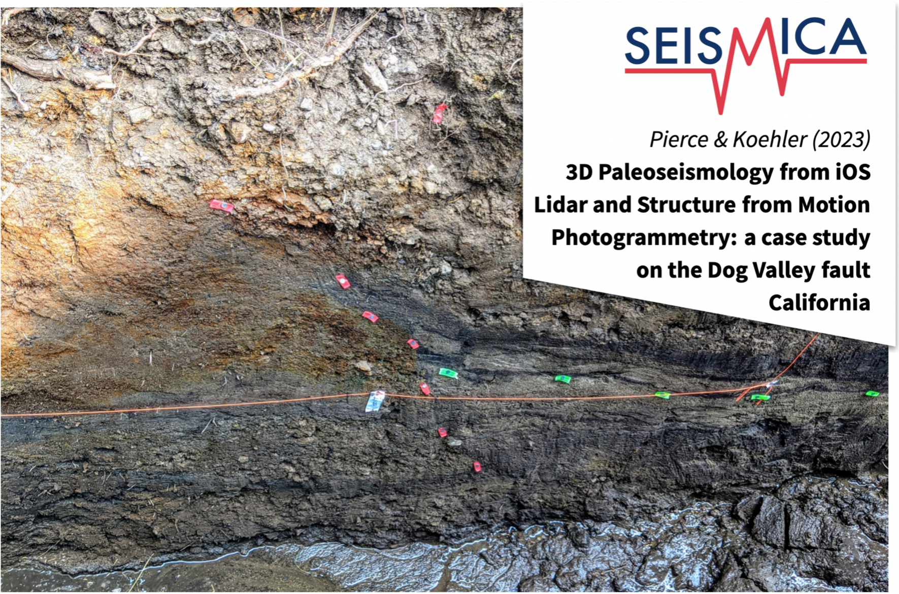
Pierce and Koehler use the lidar scanners in iPhones and iPads for earthquake trenching and to recreate 3D geological models
Read more: https://doi.org/10.26443/seismica.v2i1.208
Also, checkout their demo and presentation on this method:
https://www.youtube.com/watch?v=uio_w1CQQXQ
#earthquakescience #lidar #3dmodel #diamondopenaccess #peerreviewed #seismology #lidarscanner
Anthony Lomax
boosted

Anthony Lomax
boosted

Map of today's M5.4 #earthquake near Rio Dell in the context of the #seismicity in the region in the past year or so. This strike-slip #faulting event has depth estimates of 28-39 km, a bit deeper than the #quake from a year ago (and significantly towards E) with a similar mechanism.
Anthony Lomax
boosted

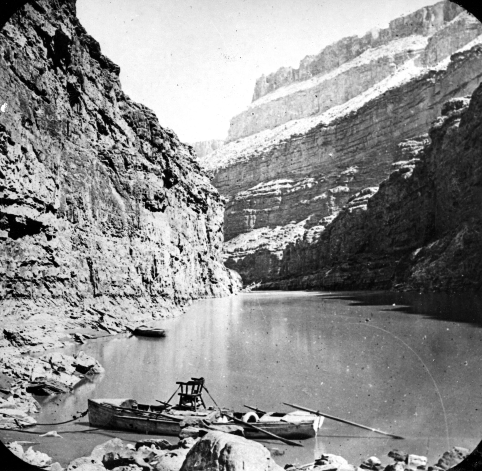
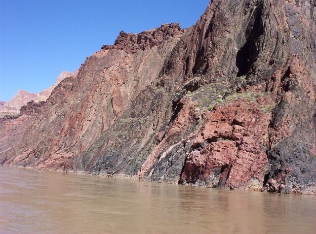
John Wesley Powell and the Great Unconformity
“Everywhere there are side gulches and cañons, so that these gulches are set about ten thousand dark, gloomy alcoves. One might imagine that this was intended for the library of the gods; and it was. The shelves are not for books, but form the stony leaves of one great book. He who would read the language of the universe may dig out letters here and there, and with them spell the words, and read, in a slow and imperfect way, but still so as to understand a little, the story of creation.”
~ John Wesley Powell, Exploration of the Colorado River of the West and Its Tributaries, pg.s 193, 194 at http://content.lib.utah.edu/cdm/ref/collection/Powell/id/365
On May 24th, 1869, at the age of 35, one-armed Civil War vet and geologist John Wesley Powell led a team of eleven men into uncharted territory, the vast unknown area around the lower Colorado River. Four boats loaded with provisions, guns for hunting, and scientific instruments to map the terrain were lowered into the river. Powell set out to follow the Colorado though the Grand Canyon despite having no knowledge of what lay ahead.
“Following the twisting, tortuous river, negotiating the rough and dangerous waters, the whirlpools and rapids, Powell’s expedition made its way down through the high plateaus of eastern Utah. They were carried through the heart of colossal, soaring rocks; they exploded through canyons and over falls, roaring down the cataracts, or when possible portaging around them. Sometimes they glided around bends that revealed vistas stupendous and sublime; other times they drifted in the deep noontime shadow cast by towering canyon walls. They clambered up the cliffs, measuring and surveying.”
Before the journey ended, the party lost a boat, a third of the food, and 3 men. Despite the hardships, the intrepid explorers made one of the most important geological journeys of all time, and although Powell did not realize the significance, discovered one of Earth's greatest mysteries.
Traveling down the Colorado, the Canyon carves its way through older and older layers of rock. Powell discovered that near the very bottom of the Grand Canyon there is a place where the 575 Mya Tapeats sandstone (Cambrian) rests (unconformably) upon the highly metamorphosed rocks of the 1.7 Bya Vishnu schist (Precambrian). This gap in time (although Powell did not realize it), represents over a billion years missing from the rock record.
This “Great Unconformity” is so large that it represents a quarter of the entire time the Earth has existed. In those billion years continents shifted, mountain ranges were formed and eroded away, oceans filled and drained, massive volcanic eruptions occurred, and life itself evolved from simple single-celled organisms to highly complex organisms. But every rock that represents those events has been eroded completely away.
Please enjoy this beautifully written and wonderfully illustrated blog, Written In Stone by Dr. Jack Share, who explains how to read the “stony leaves” that Powell spoke of and explains the true mystery of the Great Unconformity and the geology of the Grand Canyon with accompanying pictures : http://written-in-stone-seen-through-my-lens.blogspot.com/2012/01/great-unconformity-of-grand-canyon-part.html
On August 30, 1869, ninety one days after they started, the Powell expedition reached the end of its journey. They had filled in the last blank spot on the nation's map. Powell became a hero, giving public lectures and speeches, and popularized the Grand Canyon with an illustrated account of his journey (link at the top of post). By the early 1880s, he was the director of the Smithsonian and the new US Geological Survey where he worked tirelessly to protect the lands around the Grand Canyon and the Native Americans who lived there.
In 1902, a year after Powell’s death, President Theodore Roosevelt visited the Grand Canyon and declared it to be "a natural wonder absolutely unparalleled in the world . . . one of the great sights every American should see." Thanks to Powell and Roosevelt, today the Grand Canyon and its Great Unconformity is part of the Grand Canyon National Park (http://www.nps.gov/grca/index.htm), preserved and protected so that all can see its beauty and learn the secrets written in the leaves of stone.
Anthony Lomax
boosted

Hawai'i earthquake swarm caused by magma moving through 'sills' https://youtu.be/e2lT7_8Ew7g
The new color scale should work (somewhat?) well with various types of color blindness, according to https://michelf.ca/projects/sim-daltonism/
And the corresponding map view.
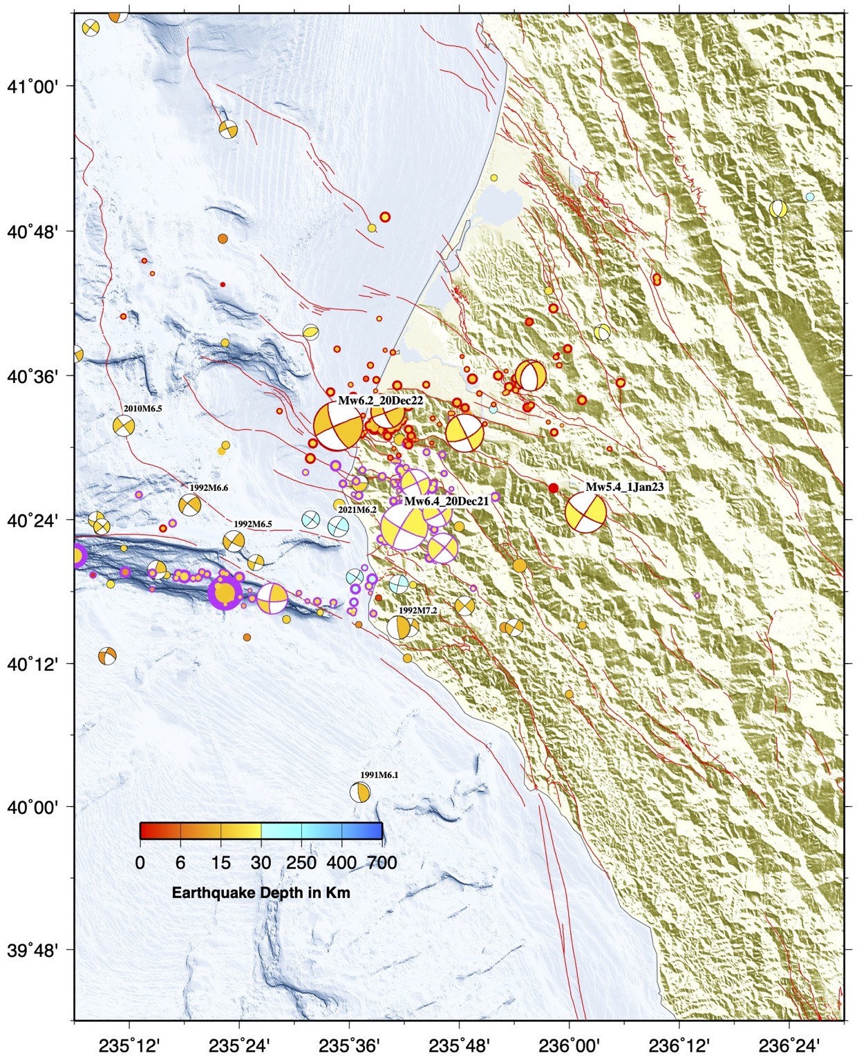
High-precision relocations of M≥2 1982 to 2021/12 done with NLL-SSST-coherence (https://doi.org/10.1029/2021JB023190), past year done with NLL-SSST.
Earthquake arrival data from service.ncedc.org/fdsnws
UPDATED: 2022-12-20 M6.4 #earthquake near Ferndale, CA: Seismicity since M6.4 (red), the past year (cyan) and back to 1982 (blue-purple). 2022-12-20 M6.4 events may be in upper part of down-going, Gorda plate or in lower part of over-riding North American plate.
And, since seismicity is only the edges and shadows of complex, 3D space-time tectonic processes, the best is an animated view in 3D!
#Earthquake happenings+tidbits, maps, #MachineLearning... I'm ALomax Scientific: earthquake monitoring and analysis.
"seismicity is only the edges and shadows of complex, 3D space-time tectonic processes"
Car free for daily life since 1976.
Joined Nov 2022
