

Jonathan Hunter @chattwjonathan@qoto.org
Meteorologist, Trucking Industry, Accident Investigation, Chattanooga FC fan, Tennessee Based, Husband, Father of 2
Joined Nov 2022
Jonathan Hunter
boosted

For those that are not big fans of the brutally cold air that will blast much of the U.S. east of the Rockies over the next five days, never fear. Warmer days are coming back in a week or so.
@1dalm - You're aren't kidding in the slightest. What a mess.
Woltever Creek - saw a talkative Green Heron there this summer along the pedestrian walkway about 1/4mi west (downstream) of there.
Video of the train derailment in Collegedale - originally posted on facebook, but I prefer twitter links still.
This massive oversized concrete girder is being delivered to the new road project to the upper left of the prior overhead shot. In fact, that appears to be the truck entering the work zone.
Huge delay incoming. These are supposed to be escorted loads. Just absolutely devastating overall besides the 2 reported injuries.
Train derailed in Collegedale, Tennessee this afternoon. 2 injuries reported. Cause under investigation.
Jonathan Hunter
boosted
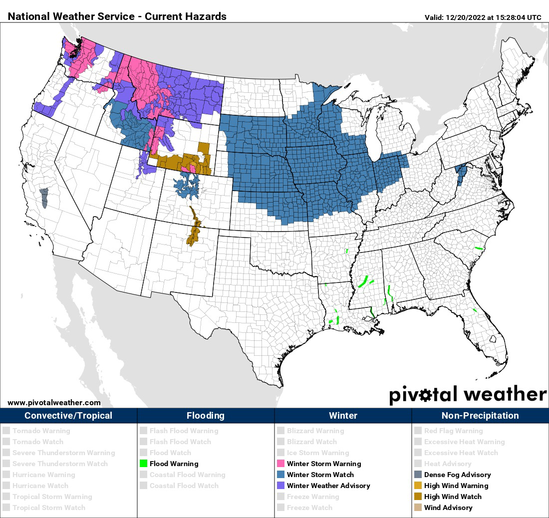
For those that will be traveling Thursday… Winter storm watches are in effect from parts of the Great Plains to the western Great Lakes. Snow, wind, and rapidly falling temperatures are likely in these areas. 
Jonathan Hunter
boosted

From Wed thru Christmas Nebraska and Iowa is gonna be facing some of the most dangerous [and deadly] weather we've seen in years. This is most definitely the Christmas to stay home unless it's a flight. -45 wind chills, 50mph winds & 4 to 7 inches of snow.
It's gonna be a long few days especially if we lose power. We're getting Kerosene for the heater thats warmed us up many times. Just remember you must have cross ventilation.
One of the funny things about being a meteorologist is that on a day like today, I was buried deep in Artic chill forecast graphics.
But when I step outside, my body is prepared for cold instead of 45 and sunny, a very regular December day in Tennessee
Jonathan Hunter
boosted

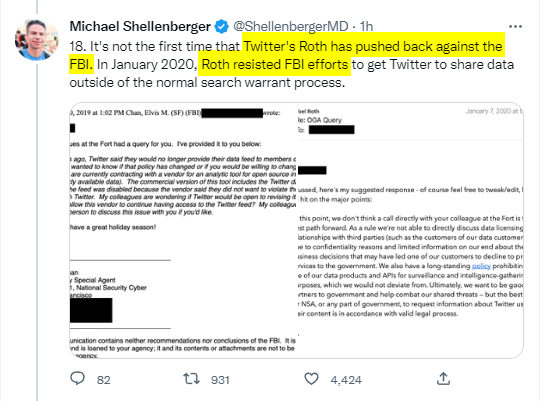
Over on the other site yet another edition of the misleadingly framed "Twitter Files" came out today... and show, once again, that Twitter actively and regularly PUSHED BACK against the FBI...
But, which the usual morons are again using as proof that Twitter was a state actor controlled by the FBI.
Jonathan Hunter
boosted

Four criminal referrals of Trump by the January 6 committee to the DOJ:
1. Obstruction of an official proceeding
2. Conspiracy to defraud the United States
3. Conspiracy to make a false statement
4 “Incite,” “Assist” or “Aird or comfort” an Insurrection
My travel plans for Christmas originally included leaving on Friday to drive from Tennessee it Ohio.
However, with the incoming winter storm, I will be changing my plans to Thursday. While I don't expect snow or much of it here on Friday, what I do expect is cold rain and increasing winds here - and a higher liklihood of snow further north.
Change your plans if you need to and check your winter preparedness checklists.
"Hey Google, play Alvin and the Chipmunks!" - 6yo
@DaveWellmanB @MrPresidentTom what would bring me even more cheer is a 3rd pick. How about you?
@MrPresidentTom
You love to see it
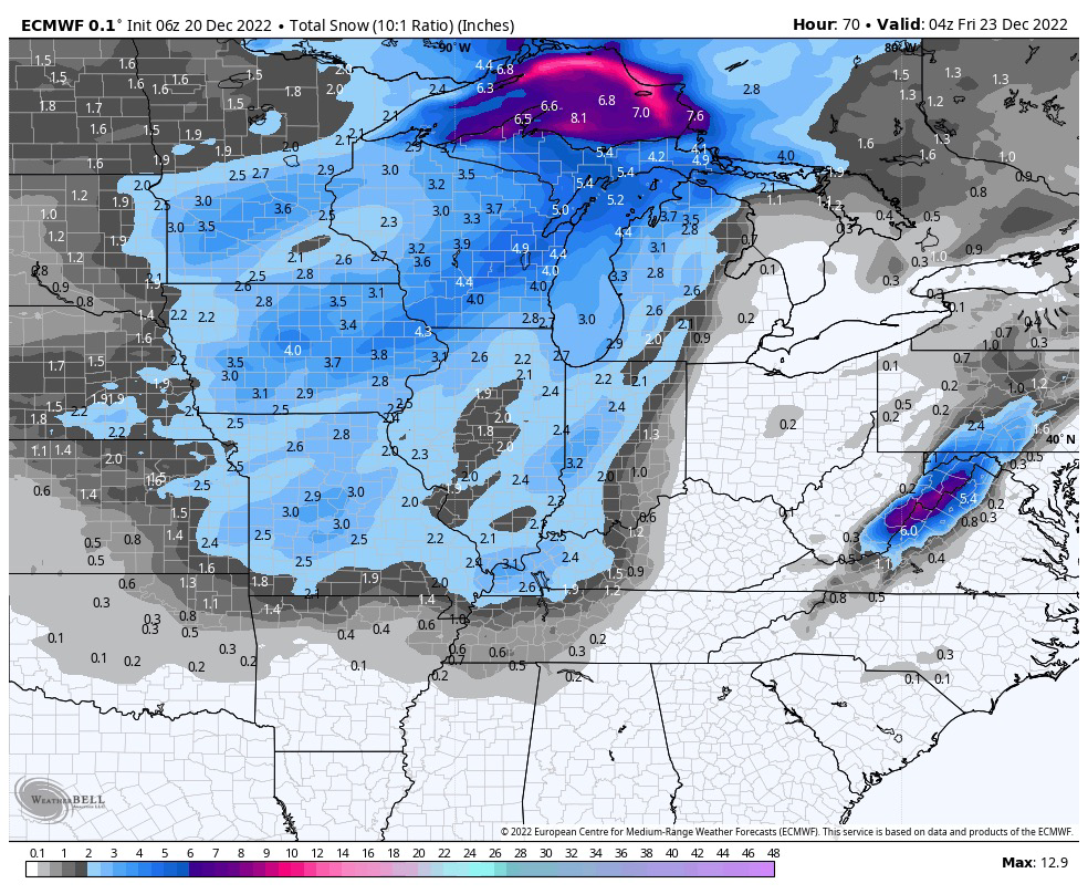
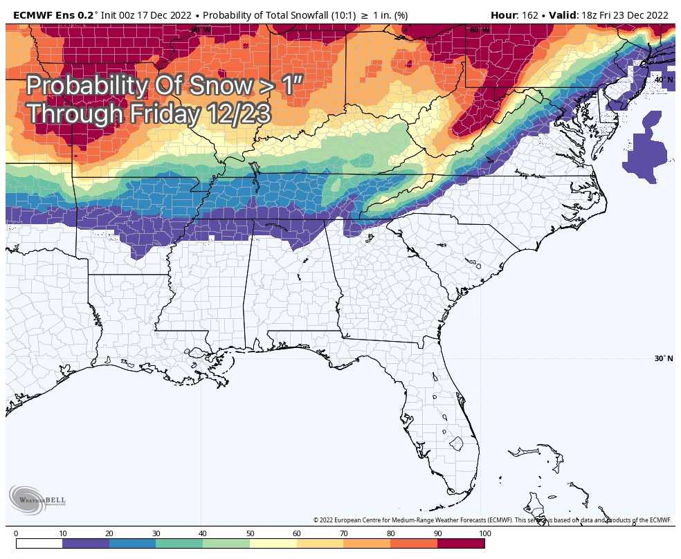
Update for SE Tennessee and chances of snow before Christmas
Snow chances are down a little bit through Christmas for Chattanooga. Not exactly a surprise for us, as weather models update with better information, and the GFS model has trended towards a different solution. For more on some of these developments, read this post from yesterday written by much a more adept person than I!
https://twitter.com/burgwx/status/1604258544831774722
That's not to say we drop to 0. In fact, we still have the same 3 threats, they've just evolved. Still individual probabilities are probably still around 40% that one of these giving us snow to see, which is again much higher than usual!
1. Monday Afternoon-Midnight
This storm has evolved in to more of a 'Split' storm with a northern and southern component, because the energy isn't quite meeting up properly. Northern Component goes off the Ohio Valley with snow. Southern component is mostly rain, but a chance of some snow on the northern side here. Again low chance of accumulation, but less now.
2. late Thurs/Fri
The GFS has started to become more consistent in making this a storm that digs deep...but ends up with the Low center staying inland and the ECMWF has more agreed with this solution, this this is where I'd lean. Mostly just rain on the front side from what it looks like, but a sweeping cold front would put light snow on the mountain tops, mostly west of the city. Still lots of possibilities.
3. Christmas Day
Energy is still showing up, but it's losing strength by the time it gets to Tennessee. will have everything to do with the prior storm.
Jonathan Hunter
boosted

Jonathan Hunter
boosted

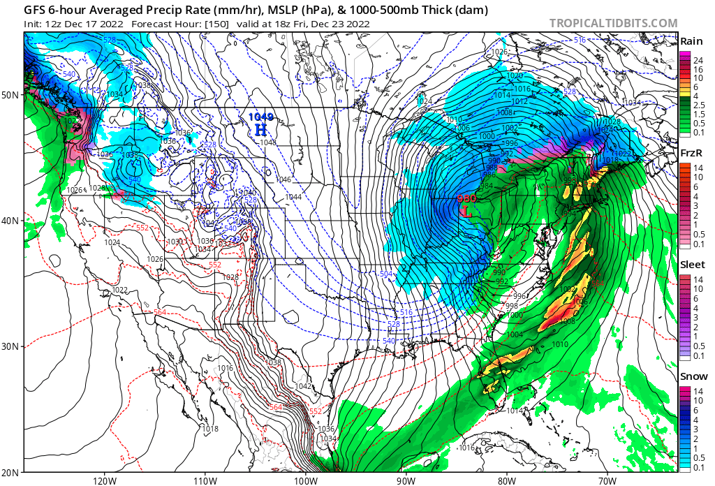
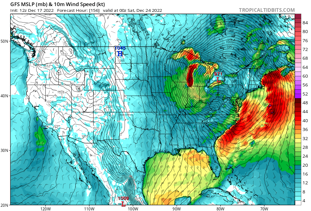
Lots of talk about the potential for a major Ohio Valley and Northeast snowstorm next week. While the track and snow impacts are still up in the air, it's certainly going to be very windy and then cold for a while after that.
Jonathan Hunter
boosted
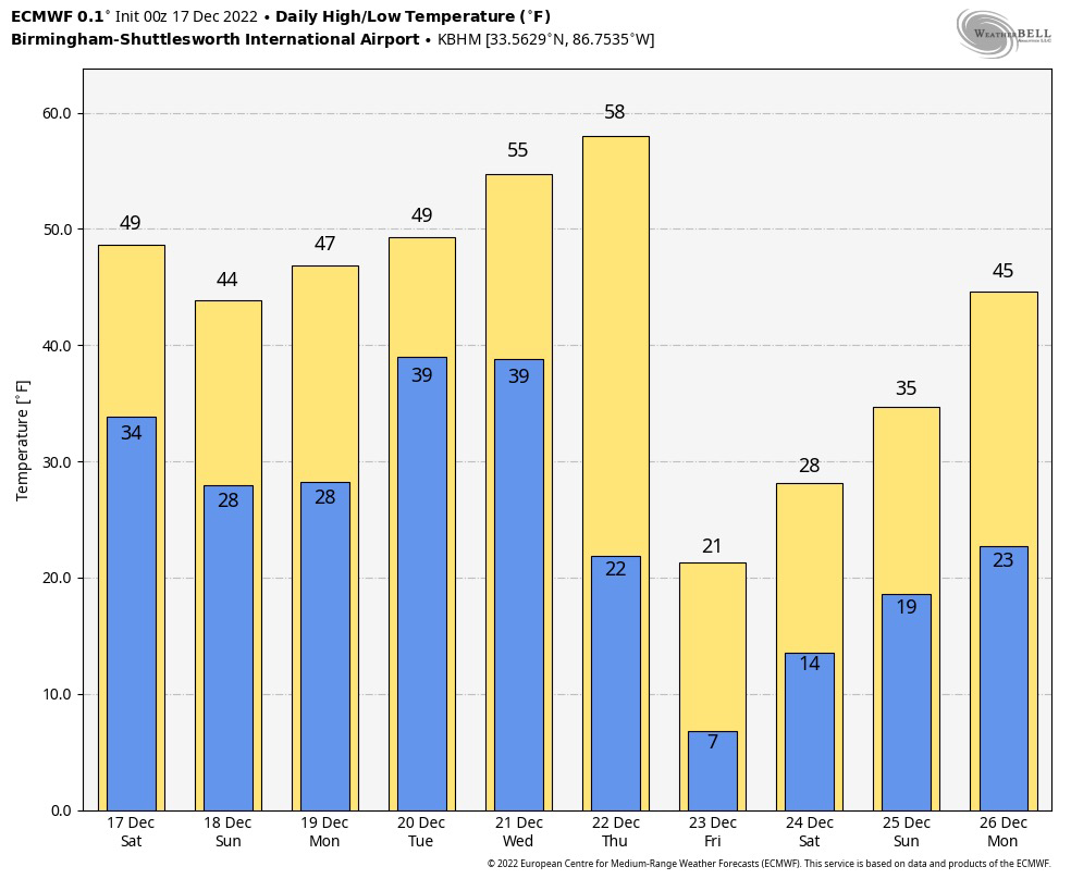
A detailed look at the Christmas weekend cold wave, and the impact on Alabama: https://www.alabamawx.com/?p=249499
Jonathan Hunter
boosted

If we want more journalists, scientists, and other professionals on here we need to encourage the ones that are already here by engaging with them about the content they’re making.
They’ll tell (and show) their friends.
Meteorologist, Trucking Industry, Accident Investigation, Chattanooga FC fan, Tennessee Based, Husband, Father of 2
Joined Nov 2022
