

Jason R. Patton @earthjay@qoto.org
- eq Reports
- https://earthjay.com
lover of mud, sand, gravel, chocolate and Earthquake Reports at https://earthjay.com
Joined Nov 2022
Jason R. Patton
boosted

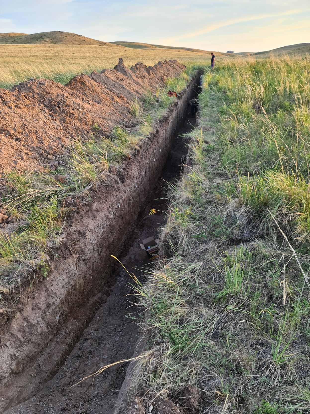
I wrote a new tutorial on how to combine iOS lidar with Structure-from-Motion photogrammetry to make accurately scaled #paleoseismic trench logs. 🚨🚨🚨 🧵
The full tutorial is available here:
https://neotectonic.github.io/posts/iOS_Surveying/
#EarthquakeReport for M 7.3 #Earthquake along outer rise near the Tonga trench
reverse (compressional) mechanism
south of analogues incl tsunamigenic 2009 M 8.1 (tho that was extensional)
https://earthquake.usgs.gov/earthquakes/eventpage/us7000ip0l/executive
learn more abt regional tectonics here
https://earthjay.com/?p=5926
Jason R. Patton
boosted

I wrote a thread about Mastodon on Twitter, it needs to be read.
https://twitter.com/pati_gallardo/status/1590485665535643649?s=46&t=hpE2Unzsn-9qKirLfo3tYA
https://twitter.com/pati_gallardo/status/1590485665535643649?s=46&t=hpE2Unzsn-9qKirLfo3tYA
Jason R. Patton
boosted

Our new paper on EPS!!
Short-period OBSs and CMT inversion using a 3D model revealed the aftershock activity off Ibaraki after the 2011 Tohoku earthquake.
Yamaya, L., Mochizuki, K., Akuhara, T., Takemura, S., et al. CMT inversion for small-to-moderate earthquakes applying to dense short-period OBS array at off Ibaraki region. Earth Planets Space 74, 164 (2022).
Jason R. Patton
boosted

I feel, as part of my initiation into this space, I must talk about my love of #Medieval elephants.
Yes, you heard me. You see, though bestiaries were very common in Western Europe, elephants were not.
So things like this happen.
"SO... lion body... got it, cloven hooves, okay, big ears and dead bird eyes... long snake face... PERFECTION."
Jason R. Patton
boosted

Space Station Flyover time-lapse movie. I captured 163 photos of the ISS flying over on August 4th. Here's a movie of them:
#space #astronomy #astrophotography #iss #nasa #photography #fediverse
in the US alone, we are now spending over $100 billion annually in response to extreme weather events.
remember this: THE GREEN NEW DEAL IS FISCALLY CONSERVATIVE
Jason R. Patton
boosted

If you download your Twitter archive it arrives wrapped as a static HTML page, which is not very useful for doing anything with, and worse: it requires the original account to be still active to do useful things like enlarge the images since they use t.co links.
So here's a Python script to convert a Twitter archive to markdown or other formats: https://github.com/timhutton/twitter-archive-parser
Now you can archive your tweets in any way you want.
Jason R. Patton
boosted

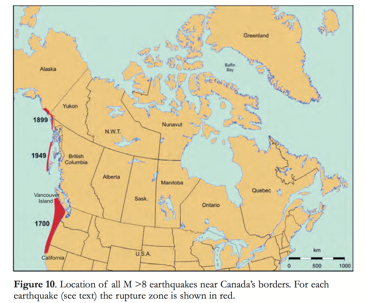
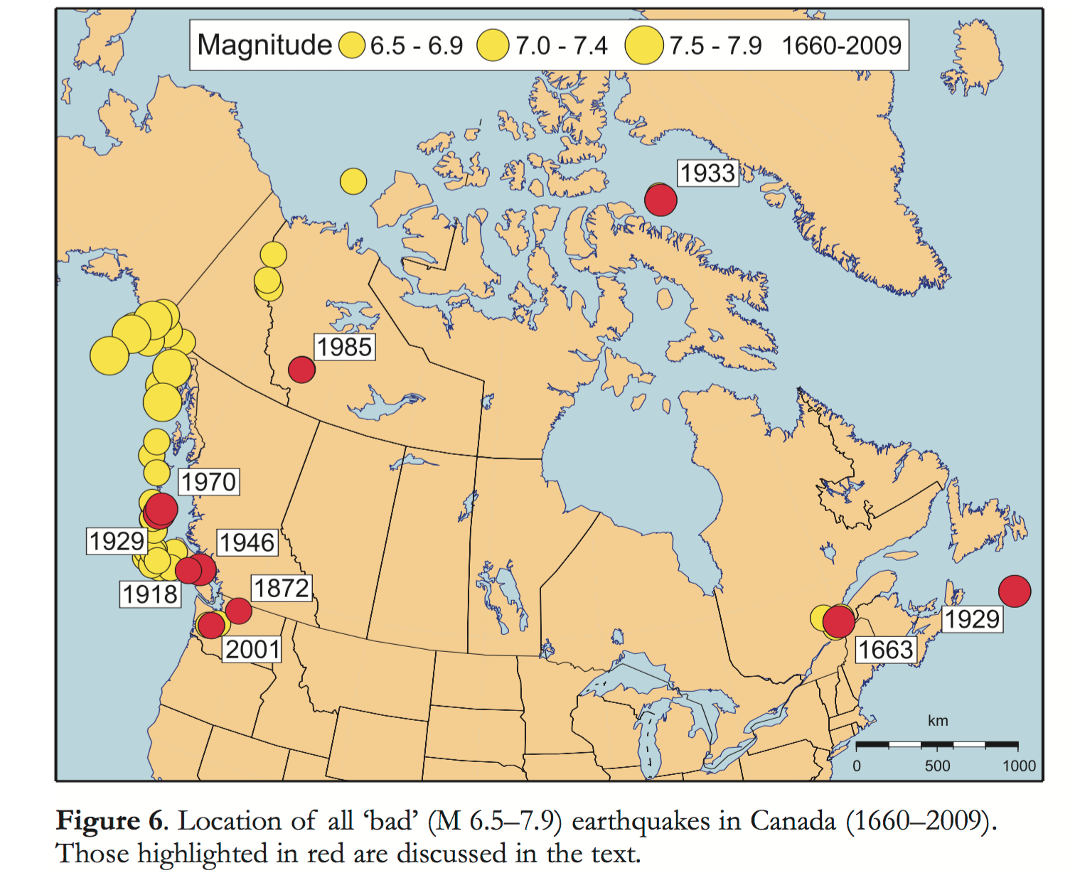
Large earthquakes in #Canada??
Not so often, but yes, some of the world’s largest #earthquakes, including:
M9 (offshore #VancouverIsland in 1700)
M8.1 and M7.8 (offshore #HaidaGwaii in 1949 and 2012, respectively).
More than 4000 earthquakes are located across Canada each year, from coast to coast to coast.
More on Canada’s earthquakes and how we minimize the impacts:
https://earthquakescanada.nrcan.gc.ca/historic-historique/GeoScienceCanada2010_Cassidyetal.pdf
https://earthquakescanada.nrcan.gc.ca/pprs-pprp/pubs/GF-GI/GEOFACT_largest-earthquakes_e.pdf
Jason R. Patton
boosted

Jason R. Patton
boosted

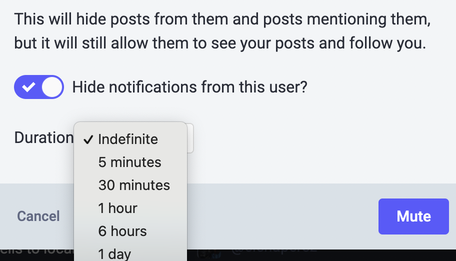
TIL that you can mute accounts for different durations of time, starting at 5 minutes.
Such a thoughtful feature — it understands that sometimes you want just to step away from someone's subject du jour, even if just for your current session. Takes some of the hostility out of the act of muting.
Jason R. Patton
boosted

Initial impression of Mastodon…
(image source thanks to @jsit: https://www.instagram.com/p/CKrqzp-F420/)
Jason R. Patton
boosted

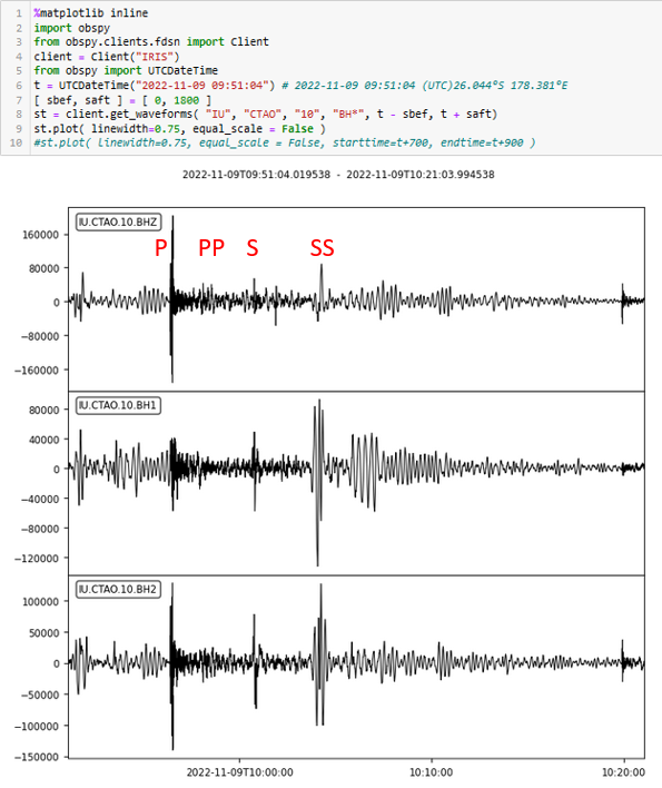
A lot of #earthquake activity today. There was a magnitude 7 south of #Fiji this morning. Thankfully deep (650 km) so not dangerous. Notice how there are no surface waves. This is the signal from IU.CTAO (Charters Towers, Australia) - I think we see P, PP, S, and SS (where PP and SS are surface returns) - do you think? Data via IRIS!
https://earthquake.usgs.gov/earthquakes/eventpage/us7000ingi/executive
Jason R. Patton
boosted

Jason R. Patton
boosted

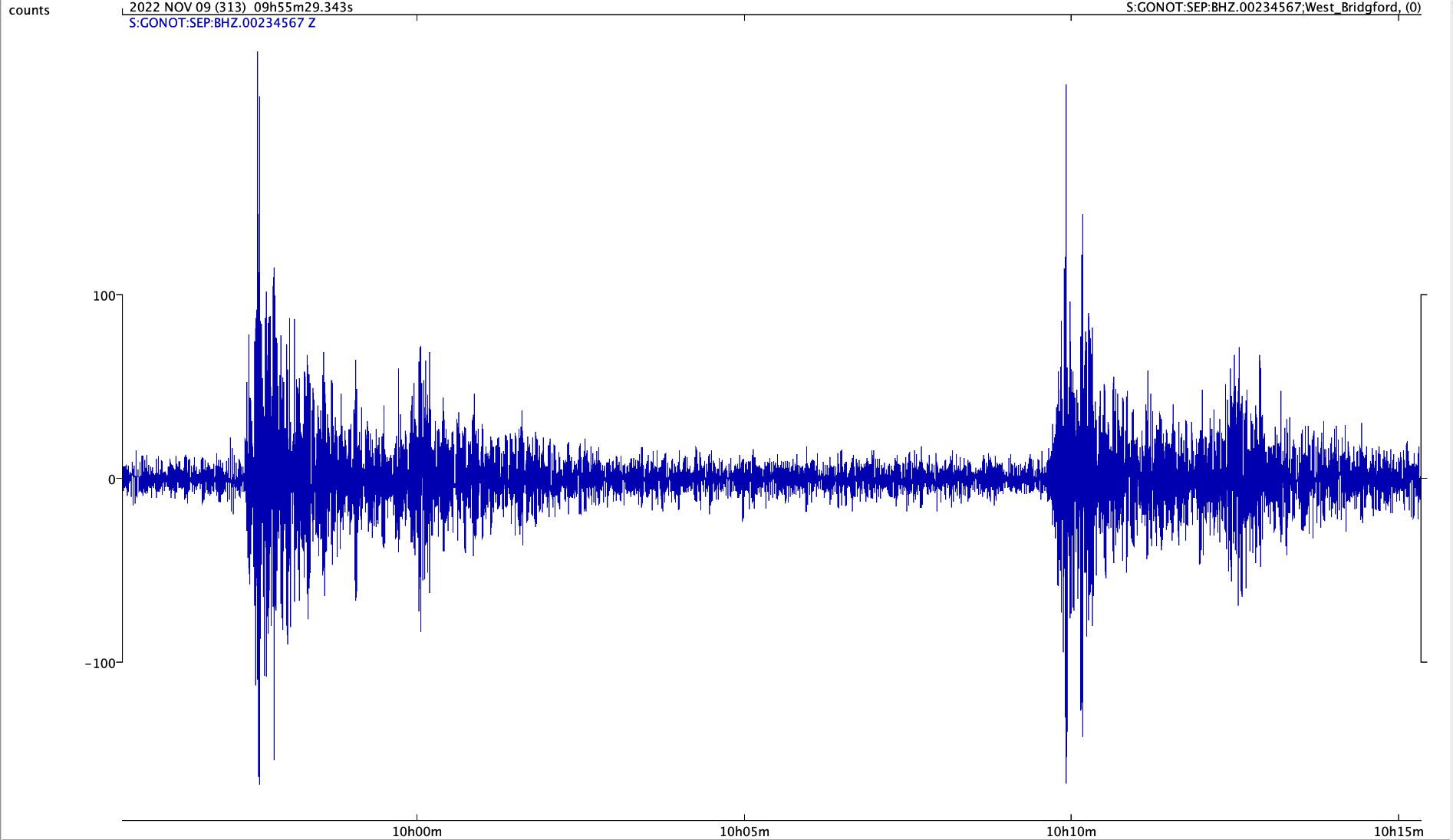
Deep M6.8 & M 7.0 #earthquakes nr Fiji at 09.38 & 09.51 UTC on 9 November 2022. PKP-wave arrivals recorded in Nottingham using "slinky" (vertical spring) seismometer
https://earthquake.usgs.gov/earthquakes/eventpage/us7000ingh/executive
https://earthquake.usgs.gov/earthquakes/eventpage/us7000ingi/executive
Jason R. Patton
boosted

Morning folks, time for my first Mastodon thread (!)
Ahead of the #midterms tomorrow, I want to talk about the tragic politicisation of science in the US.
It’s hard to pinpoint exactly when the Republicans became the anti-science party, but the process probably began in the 1980s, when the Christian right first emerged as a major force in conservative American politics.
Since then, the journey has been smooth and swift, and there is now a stunning partisan divide on confidence in science 😥
Jason R. Patton
boosted
@JochenFromm indeed! #EarthquakeToot
it appears to be related to the Pesaro mare-Cornelia fault (using the Database of Individual Seismogenic Sources 3.2.0 in the google map).
this fault may be between 120-160km. using wells & coppersmith mag relations with subsurface rupt length, this fault could produce a mag M 7.7-7.7 #Earthquake
there were 2 events of similar mag in the past century. map below shows 1922-2022 M>5.5.
felt reports along the coast reached MMI 7
geoscope carte shows a thrust mechanism, probably on fault plane dipping to the west, unless this is on a fault antithetic to the mapped fault (so would be reverse dipping to the east)
learn more about the regional tectonics from this #EarthquakeReport page (and included linked report pages) here https://earthjay.com/?p=4427
USGS page https://earthquake.usgs.gov/earthquakes/eventpage/us7000infp/executive
IPGP geoscope page
http://geoscope.ipgp.fr/index.php/en/catalog/earthquake-description?seis=us7000infp
Jason R. Patton
boosted

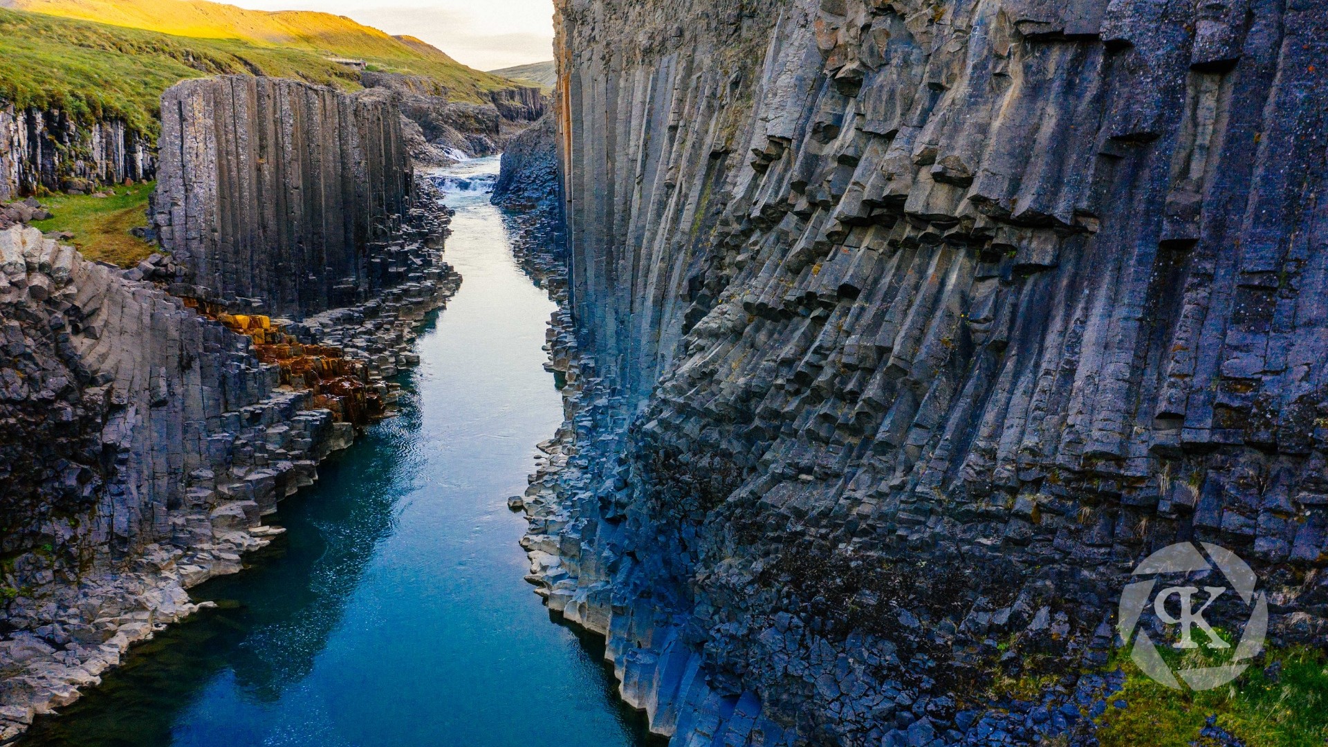
#Photography has been a natural complement to the #fieldwork that I've performed over the years. It's afforded me opportunities to visit places like this canyon in northern #Iceland. The columnar basalt lining the canyon sidewalls are #geologist's dream!
This view was captured from my #drone during a trip in 2019. I had just finished performing fieldwork focused on #dronemapping several #periglacial and #glacial sites across the island and took the last week of the trip for some sightseeing!
Jason R. Patton
boosted
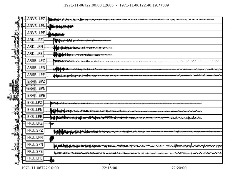
As Stephen Schwartz points out on Twitter, today is the 51st anniversary of the United States' largest ever underground nuclear test - about 5 Megatons at Amchitka Island, Alaska.
The waveforms displayed are freely available from the following site - all digitized from analog seismic stations in the Former Soviet Union (in Central Asia)
https://www.ldeo.columbia.edu/res/pi/Monitoring/Arch/digitized_analog_FSUarchive.html
- eq Reports
- https://earthjay.com
lover of mud, sand, gravel, chocolate and Earthquake Reports at https://earthjay.com
Joined Nov 2022
