

Jason R. Patton @earthjay@qoto.org
- eq Reports
- https://earthjay.com
lover of mud, sand, gravel, chocolate and Earthquake Reports at https://earthjay.com
Joined Nov 2022
Jason R. Patton
boosted

Jason R. Patton
boosted

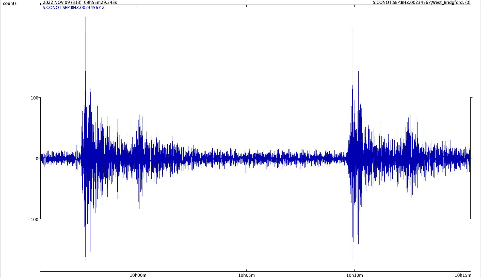
Deep M6.8 & M 7.0 #earthquakes nr Fiji at 09.38 & 09.51 UTC on 9 November 2022. PKP-wave arrivals recorded in Nottingham using "slinky" (vertical spring) seismometer
https://earthquake.usgs.gov/earthquakes/eventpage/us7000ingh/executive
https://earthquake.usgs.gov/earthquakes/eventpage/us7000ingi/executive
Jason R. Patton
boosted

Morning folks, time for my first Mastodon thread (!)
Ahead of the #midterms tomorrow, I want to talk about the tragic politicisation of science in the US.
It’s hard to pinpoint exactly when the Republicans became the anti-science party, but the process probably began in the 1980s, when the Christian right first emerged as a major force in conservative American politics.
Since then, the journey has been smooth and swift, and there is now a stunning partisan divide on confidence in science 😥
Jason R. Patton
boosted
@JochenFromm indeed! #EarthquakeToot
it appears to be related to the Pesaro mare-Cornelia fault (using the Database of Individual Seismogenic Sources 3.2.0 in the google map).
this fault may be between 120-160km. using wells & coppersmith mag relations with subsurface rupt length, this fault could produce a mag M 7.7-7.7 #Earthquake
there were 2 events of similar mag in the past century. map below shows 1922-2022 M>5.5.
felt reports along the coast reached MMI 7
geoscope carte shows a thrust mechanism, probably on fault plane dipping to the west, unless this is on a fault antithetic to the mapped fault (so would be reverse dipping to the east)
learn more about the regional tectonics from this #EarthquakeReport page (and included linked report pages) here https://earthjay.com/?p=4427
USGS page https://earthquake.usgs.gov/earthquakes/eventpage/us7000infp/executive
IPGP geoscope page
http://geoscope.ipgp.fr/index.php/en/catalog/earthquake-description?seis=us7000infp
Jason R. Patton
boosted

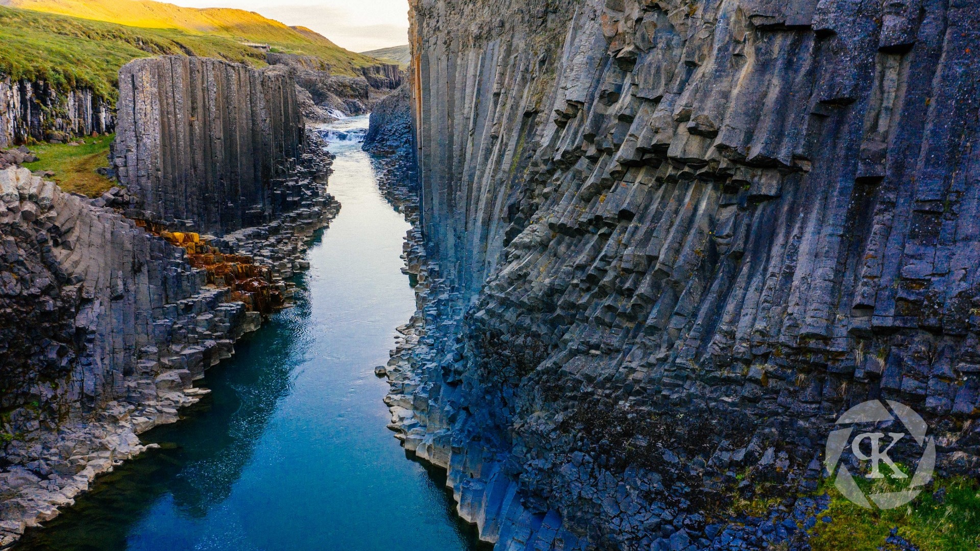
#Photography has been a natural complement to the #fieldwork that I've performed over the years. It's afforded me opportunities to visit places like this canyon in northern #Iceland. The columnar basalt lining the canyon sidewalls are #geologist's dream!
This view was captured from my #drone during a trip in 2019. I had just finished performing fieldwork focused on #dronemapping several #periglacial and #glacial sites across the island and took the last week of the trip for some sightseeing!
Jason R. Patton
boosted

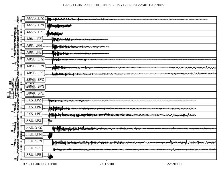
As Stephen Schwartz points out on Twitter, today is the 51st anniversary of the United States' largest ever underground nuclear test - about 5 Megatons at Amchitka Island, Alaska.
The waveforms displayed are freely available from the following site - all digitized from analog seismic stations in the Former Soviet Union (in Central Asia)
https://www.ldeo.columbia.edu/res/pi/Monitoring/Arch/digitized_analog_FSUarchive.html
Jason R. Patton
boosted

Jason R. Patton
boosted

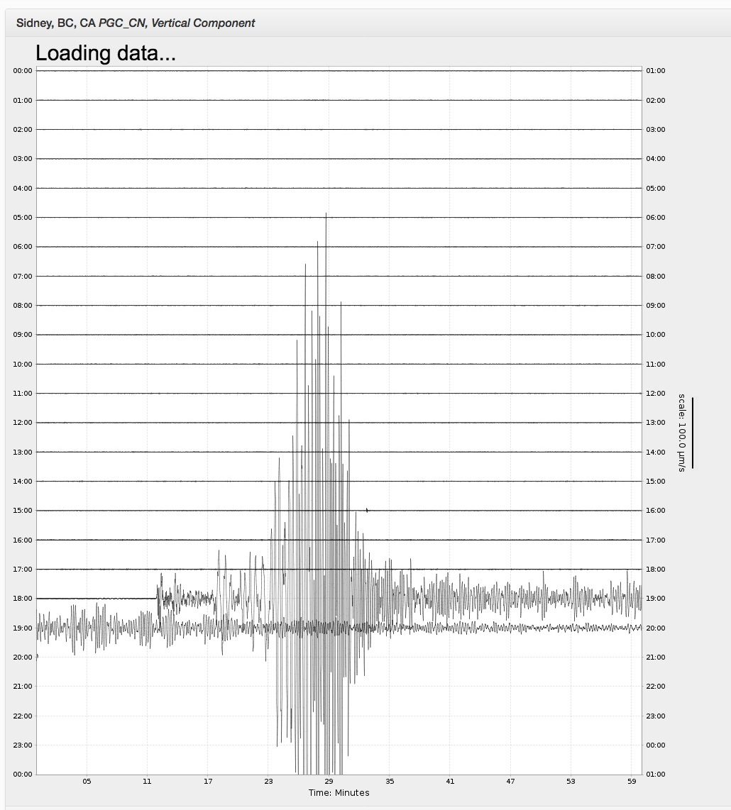
Wondering what’s #shaking in your part of the world?
See the live seismograms that record #earthquakes (near and far), #windstorms and any other event that might cause the ground to shake (could be a moose walking by).
In #Canada, see the last hour of ground shaking here:
https://earthquakescanada.nrcan.gc.ca/stndon/wf-fo/index-en.php
Around the world, see 24-hour seismograms:
IRIS:
https://www.iris.edu/app/station_monitor/#Today//map/
Raspberry Shake network:
https://stationview.raspberryshake.org/#/
Jason R. Patton
boosted

6,319,301 accounts
+3,535 in the last hour
+113,804 in the last day
+502,309 in the last week
Jason R. Patton
boosted

Have just realised that #academics can use @ORCID_Org to
#verify themselves.
Just include your full mastodon link (like this: https://mas.to/@marekmcgann) in the "Websites and Social Links" section in ORCID, then include link to your ORCID record in your Mastodon profile.
Hurray for distributed digital identities!
Jason R. Patton
boosted
The absolute BEST thing about Mastodon? No DMs… ☠️
Jason R. Patton
boosted

Hello! As an #introduction to me, I am a #geologist who studies #topography and how it reflects active #tectonics with a special focus on bedrock #rivers.
I am passionate about #openaccess publishing and #opensource software development for geoscientists. I'm looking to connect with other twitter refugees and new folks as well!
Jason R. Patton
boosted

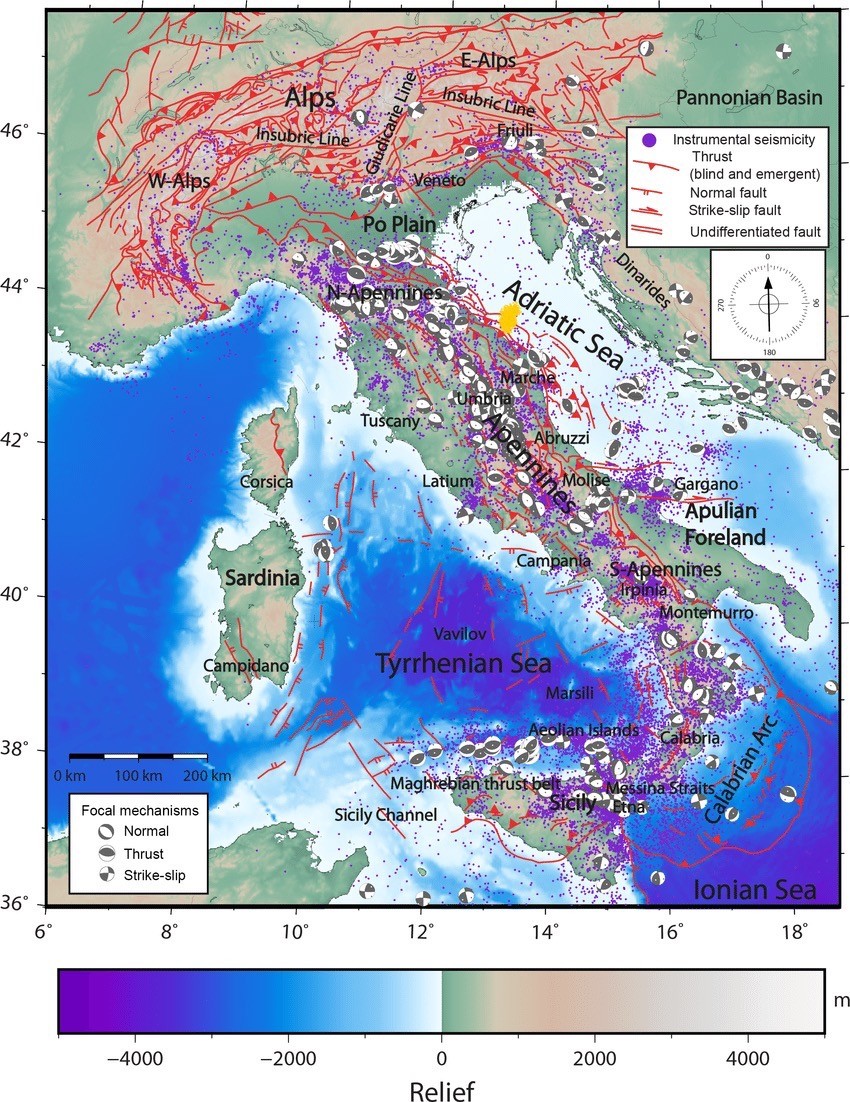
Early reports from multiple agencies indicate a shallow #earthquake occurred in #Italy, M5.5-6.0, widely felt. Approximate location is shown on a #tectonic map from Trippetta et al. 2019 with a yellow blob.
Jason R. Patton
boosted
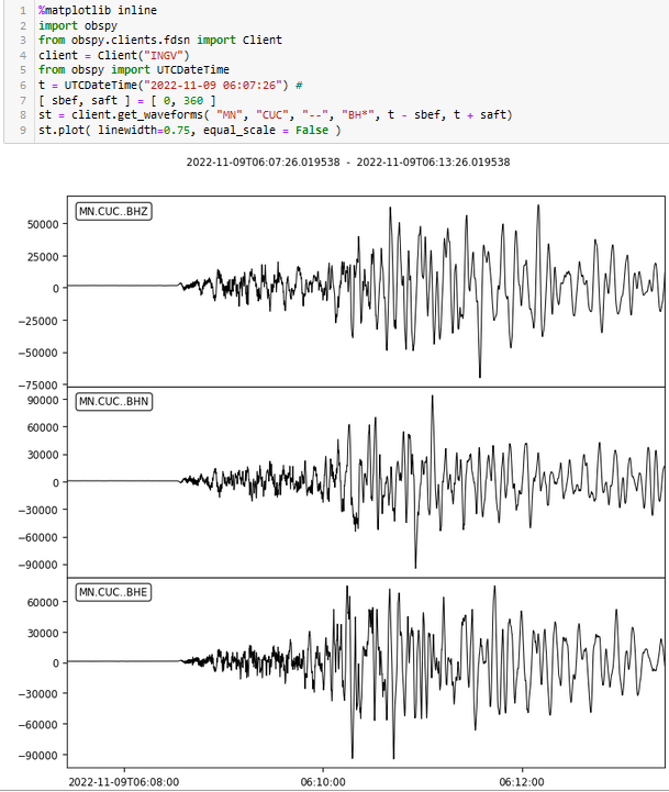
Magnitude 5.7 #earthquake in Adriatic Sea, East of Central #Italy about 15 minutes ago (2022-11-09 06:07:26) Data from station MN.CUC (Castrocucco, Italy) courtesy of INGV, Italy (https://www.emsc-csem.org/Earthquake/earthquake.php?id=1187048#scientific)
Jason R. Patton
boosted

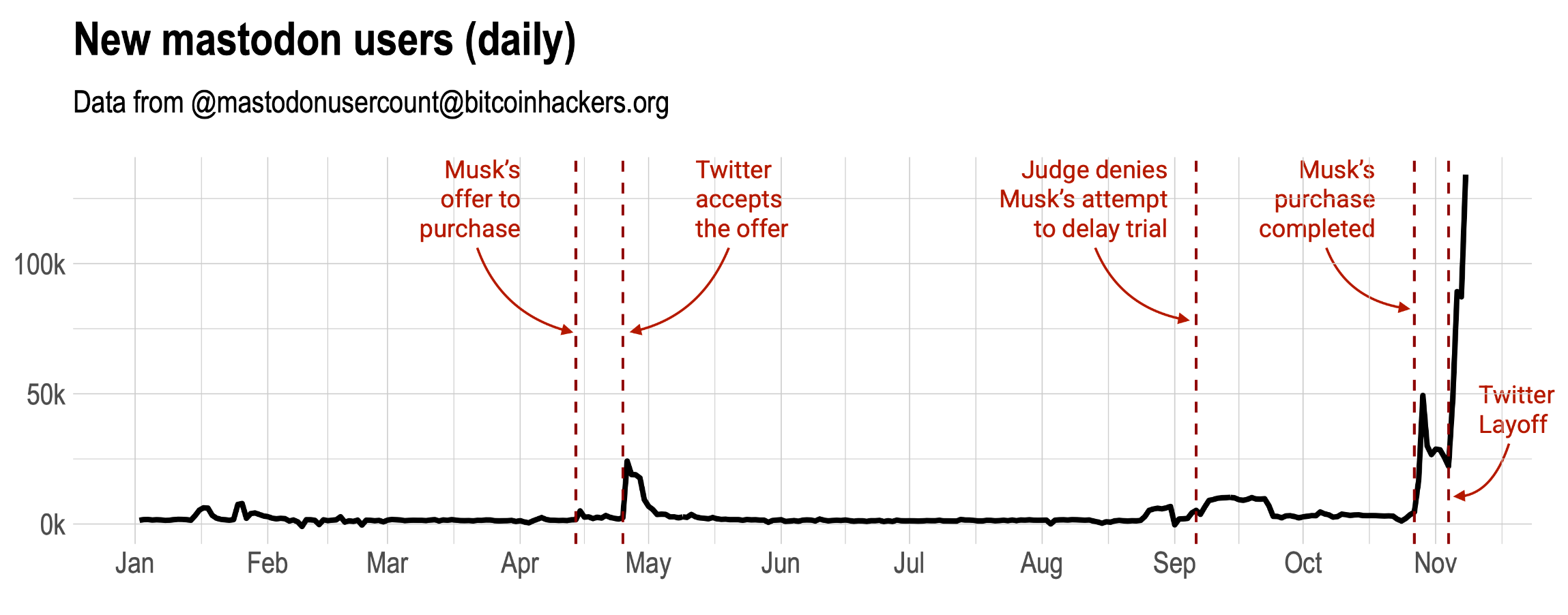
Tuesday update on the #mastodon growth. 135k (!!) users join yesterday. Also, I'm zooming out the plot to see the evolution in the number of new users through the last year. I'm going to need a logarithm scale pretty soon 😎
Jason R. Patton
boosted

22,632 accounts
+8 in the last hour
+744 in the last day
+4,414 in the last week
#EarthquakeReport #EarthquakeToot for #OTD in 2018 M 6.7 earthquake
along the Jan Mayen transform fault offshore of #Greenland and #iceland
along the Mid Atlantic Ridge plate boundary between the North America plate and the Eurasia plate
left-lateral strike-slip #earthquake mechanism
learn more about the regional tectonics here
https://earthjay.com/?p=7972
Jason R. Patton
boosted

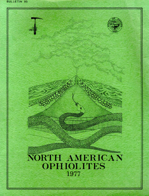
I love the graphic on the cover of this 1977 Bulletin from the Oregon Dept. of #Geology on North American #Ophiolites.
#EarthquakeReport for the M 7.6 (likely) subduction zone #Earthquake in #Mexico on 19 Sept 2022 #TootToot #toot
catching up on reports that happened after my website went down
generated 0.6-1.7m wave height #Tsunami
probably triggered landslides/induced liquefaction
report (and higher resolution figures) here:
https://earthjay.com/?p=10472
- eq Reports
- https://earthjay.com
lover of mud, sand, gravel, chocolate and Earthquake Reports at https://earthjay.com
Joined Nov 2022
