

Jason R. Patton @earthjay@qoto.org
- eq Reports
- https://earthjay.com
lover of mud, sand, gravel, chocolate and Earthquake Reports at https://earthjay.com
Joined Nov 2022
#EarthquakeReport for M5.4 #Gempa #Earthquake offshore of #Sumatra #Indonesia
Possibly aftershock from 2012 Wharton Basin M8.6 earthquake sequence
Read about 2012 earthquakes earthjay.com/?p=294
https://earthquake.usgs.gov/earthquakes/eventpage/us6000lb60/executive
#EarthquakeReport for #OTD in 2016 M 4.9 #Earthquake offshore of #Oregon #California
classic left-lateral strike-slip earthquake along reactivated faults within the Gorda plate
read more: https://earthjay.com/?p=4320
Jason R. Patton
boosted

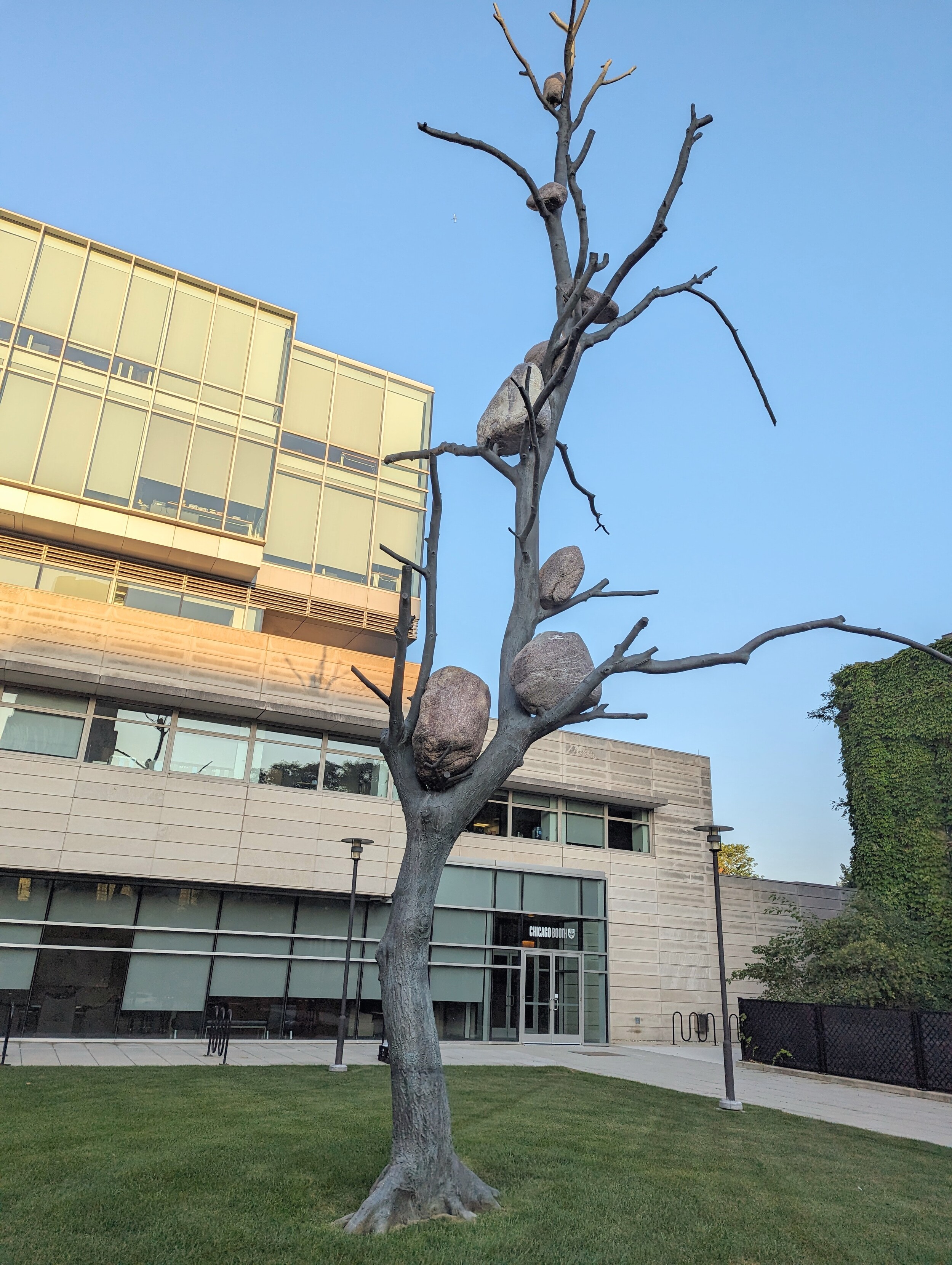
I'm a geologist and this isn't cute or funny. Rocks only climb trees like this when they're very stressed.
#EartthquakeReport #EarthquakeToot #TsunamiReport for M7.2 #Earthquake & #Tsunami offshore of #Alaska
megathrust interface eq in area of low slip '20 M 7.8
tsunami at Sand Point
read more about '20 (in green) '21 (blue) sequences in '21 report https://earthjay.com/?p=9849
https://earthquake.usgs.gov/earthquakes/eventpage/us7000kg30/executive
Jason R. Patton
boosted

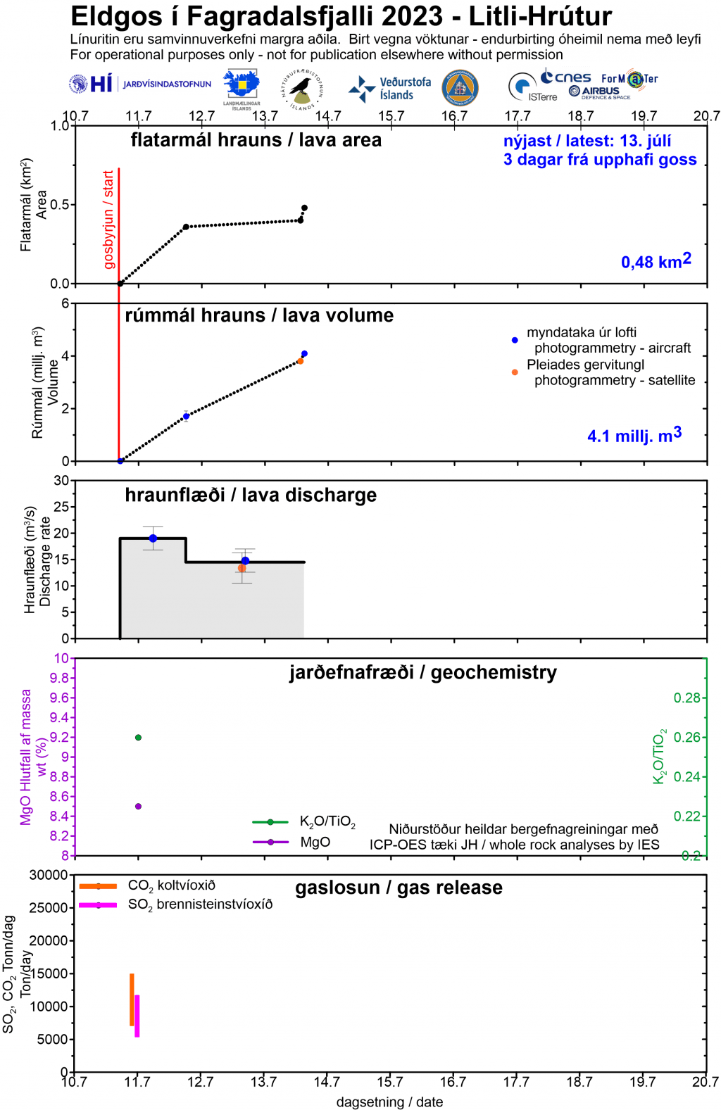
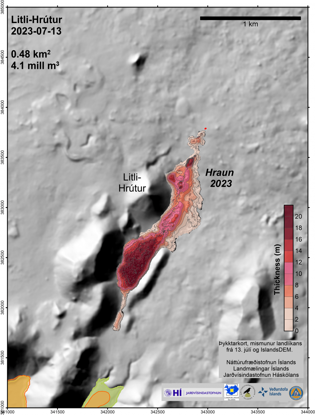
Data from #LitliHrutur eruption as of July 13 by #Iceland Institute of Earth Sciences - graph in Icelandic & English; maps in Icelandic - "hraun" is Icelandic for lava and marks lava flows from 2021, 2022 & 2023. https://jardvis.hi.is/is/eldgos-vid-litla-hrut-nidurstodur-maelinga-13-juli #Fagradalsfjall #volcano🌋 #geology
Jason R. Patton
boosted

(MAP) Here’s Where They're Planning New Murals for the 2023 Eureka Street Art Festival
https://lostcoastoutpost.com/2023/jul/15/map-heres-where-theyre-planning-new-murals-2023-eu/
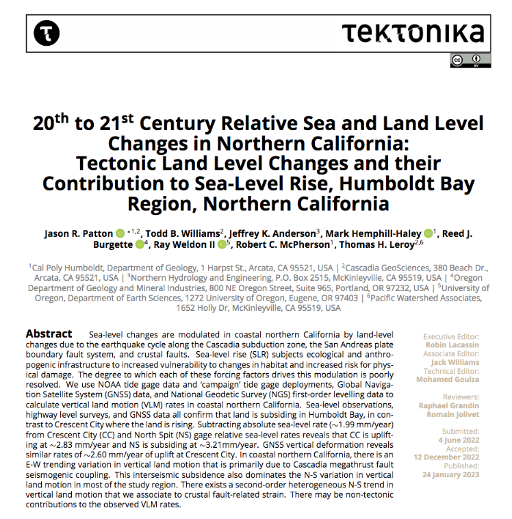
read our paper on slip deficits calculated for megathrust and crustal faults in southern #Cascadia subduction zone & #Mendocino triple junction in northern #California
we used 3 geodetic datasets: GNSS, benchmark leveling, tide gage
Jason R. Patton
boosted

Today, #TEKTONIKA #DOAJ has published its first paper ! 🎉
20th to 21st Century Relative Sea and Land Level Changes in Northern #California - by J. Patton @earthjay et al.
https://tektonika.online/index.php/home/article/view/6
Toot it, share it, read it FREE !
Jason R. Patton
boosted

@wearetektonika @earthjay @RobinLacassin As one of the reviewers of this work, I am thrilled to see my review report published in #openaccess, along with the paper. This is a big step forward toward #transparency of the #peerreview process, and recognition of the work involved in reviewing scientific papers. Congratulations to the authors for their paper, and to @wearetektonika editors for their work!
#EarthquakeReport #EarthquakeToot for #OTD in 2019 M7.2 #Gempa #Earthquake in #Halmahera #Indonesia
onshore crustal strike-slip fault earthquake yet generated a modest #Tsunami
felt widely
potential for triggered landslides and induced liquefaction
read report here
https://earthjay.com/?p=8781
#EarthquakeReport #EarthquakeToot for M 6.4 #Earthquake in Mendocino triple junction (Triangle of Doom) region
aftershocks suggest left-lateral strike-slip in Gorda plate
felt broadly, about 92%g in Ferndale
read more from last year's report
https://earthjay.com/?p=10125
https://earthquake.usgs.gov/earthquakes/eventpage/nc73821036/executive
hi res map here
https://earthjay.com/earthquakes/20221220_norcal/20221220_norcal_interpretation.jpg
Jason R. Patton
boosted

BREAKING: The European Union has reportedly warned Elon Musk that Twitter could be BANNED in Europe unless the platform abides by the EU’s strict rules on content moderation.
That sounds significant. #Twitter
Jason R. Patton
boosted

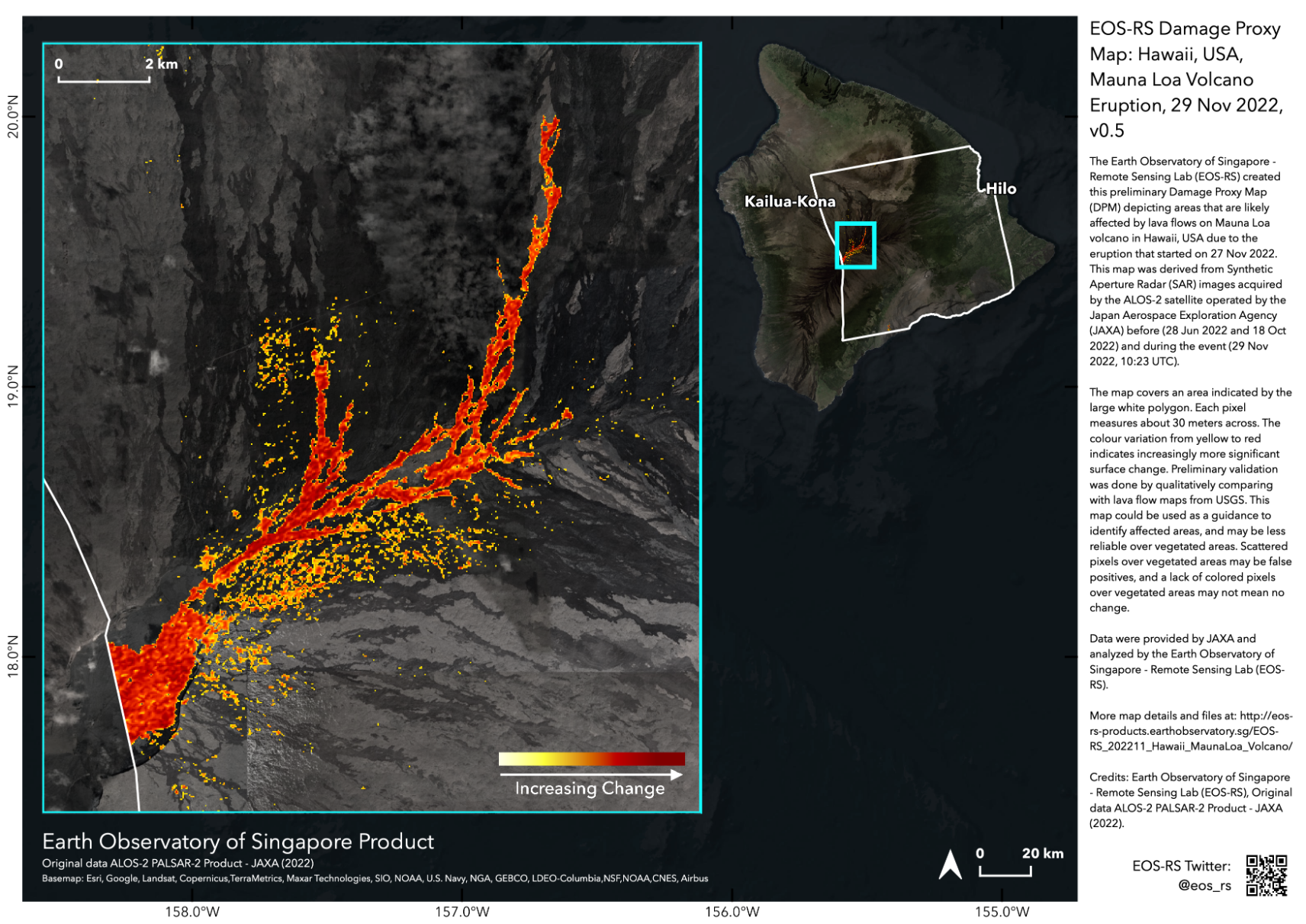
Our partners at the Earth Observatory of Singapore Remote Sensing lab has processed a map of Mauna Loa #MaunaLoa surface change from JAXA ALOS-2 radar images acquired yesterday and earlier this year. We call this a Damage Proxy Map, and in this case it shows the areas covered by new lava flows at (29 Nov 2022, 10:23 UTC).
Data products available at https://eos-rs-products.earthobservatory.sg/EOS-RS_202211_Hawaii_MaunaLoa_Volcano/
Jason R. Patton
boosted

The Economist this morning:
On Tuesday the World Meteorological Organisation published, for the first time, an evaluation of global water resources. The findings are bleak: much of the world experienced unusually dry conditions in 2021. Although this was partly due to La Niña—a temporary weather pattern that influences the distribution of rains and winds—it is mostly a result of climate change, which is driving up temperatures and worsening droughts. These changes affect economies: in Britain and Europe alone, droughts currently cause around $9bn in losses each year.
Jason R. Patton
boosted
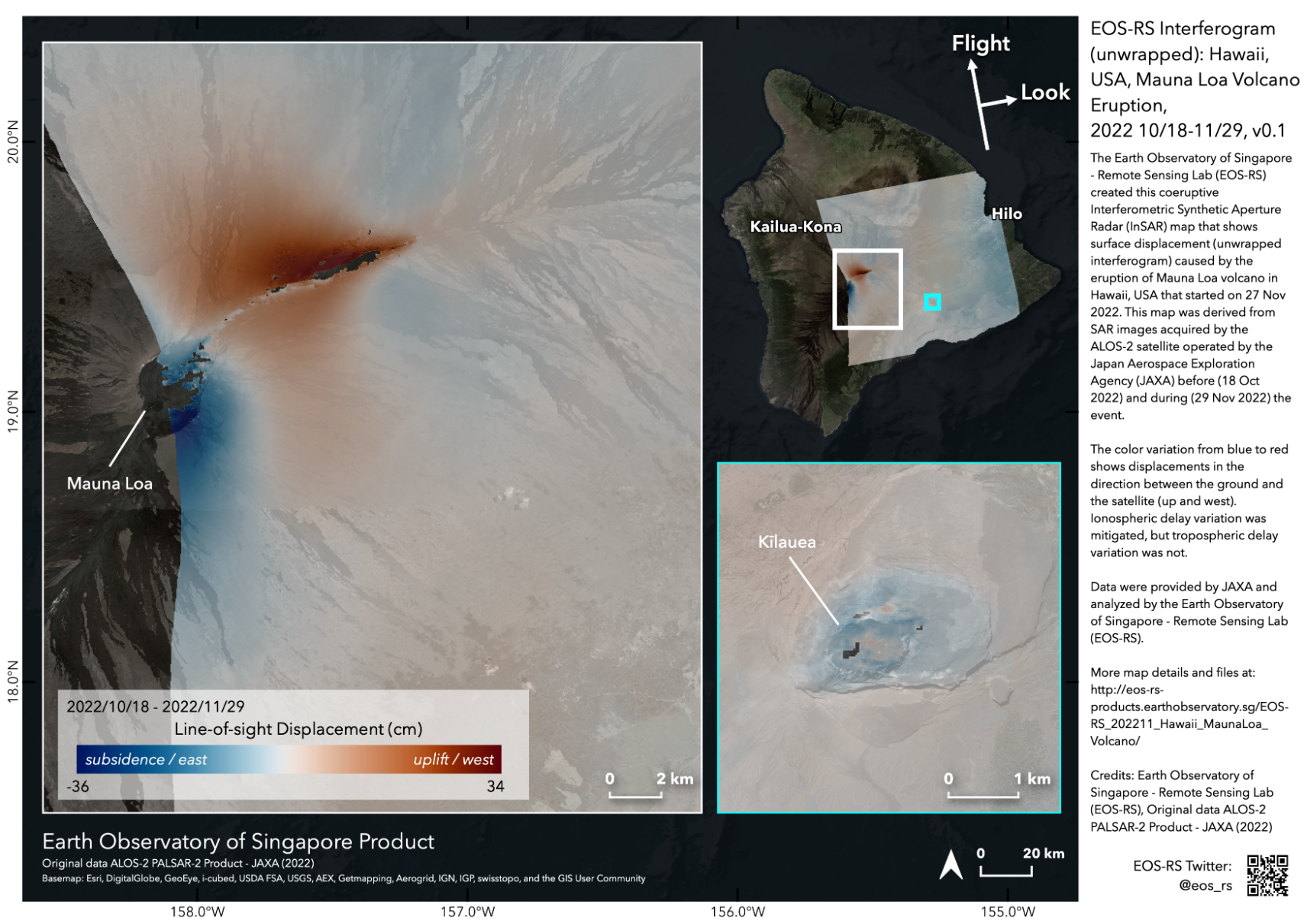
Our partners at the Earth Observatory of Singapore Remote Sensing lab made map of surface displacements for Mauna Loa #MaunaLoa east side from JAXA ALOS-2 radar images acquired yesterday and earlier this year. This #InSAR displacement map shows motion of surface to east and up in this case. The northeast rift zone has expanded due to new magma moving there and the summit has moved down during #volcano #eruption at (29 Nov 2022, 10:23 UTC).
Data products available at https://eos-rs-products.earthobservatory.sg/EOS-RS_202211_Hawaii_MaunaLoa_Volcano/
Jason R. Patton
boosted

Set your DVR to record! 📺
Many of your favorite earth scientists (including me - I’m one of your favorites, right? 😉) will be talking about the San Andreas fault on the Discovery Channel on Dec. 15th at 9pm ET!
The show is part of a docuseries called “Brink of Disaster” 🙄. I’m hopeful that the content is better than the title!
#science #earthquake #scicomm #sanandreas #fault #southerncalifornia
Jason R. Patton
boosted

Regarding the earthquakes felt around Taupō today, I hope everyone there managed to get some sleep.
"...this activity is almost all aftershocks of the M5.6 earthquake... The most likely scenario is there will be a number of smaller aftershocks which will taper off, much like we experienced with the M 5 in September 2019 with a similar aftershock sequence.”
#Taupō #NZTwits #NewZealand #Earthquake #volcano #Aoteara
More info:
https://www.nzherald.co.nz/rotorua-daily-post/news/lake-taupo-quake-tsunami-destroys-boats-damages-foreshore-150-aftershocks-following-56-tremor/OYSTQG3EWRBAZPHBXL3PEH62YA/
Jason R. Patton
boosted

Joy and sadness can coexist. Although it is difficult to notice it during life's storms, having perspective can bring balance.
It's -30ºC/-22ºF temperature today in the environment around me. From the lake near my cabin in the wilderness of the Yukon, I'm sending joy, hope and positivity.
***
Saxophone: Todd MacLean of PEI
Drum: Gurdeep Pandher
Jason R. Patton
boosted

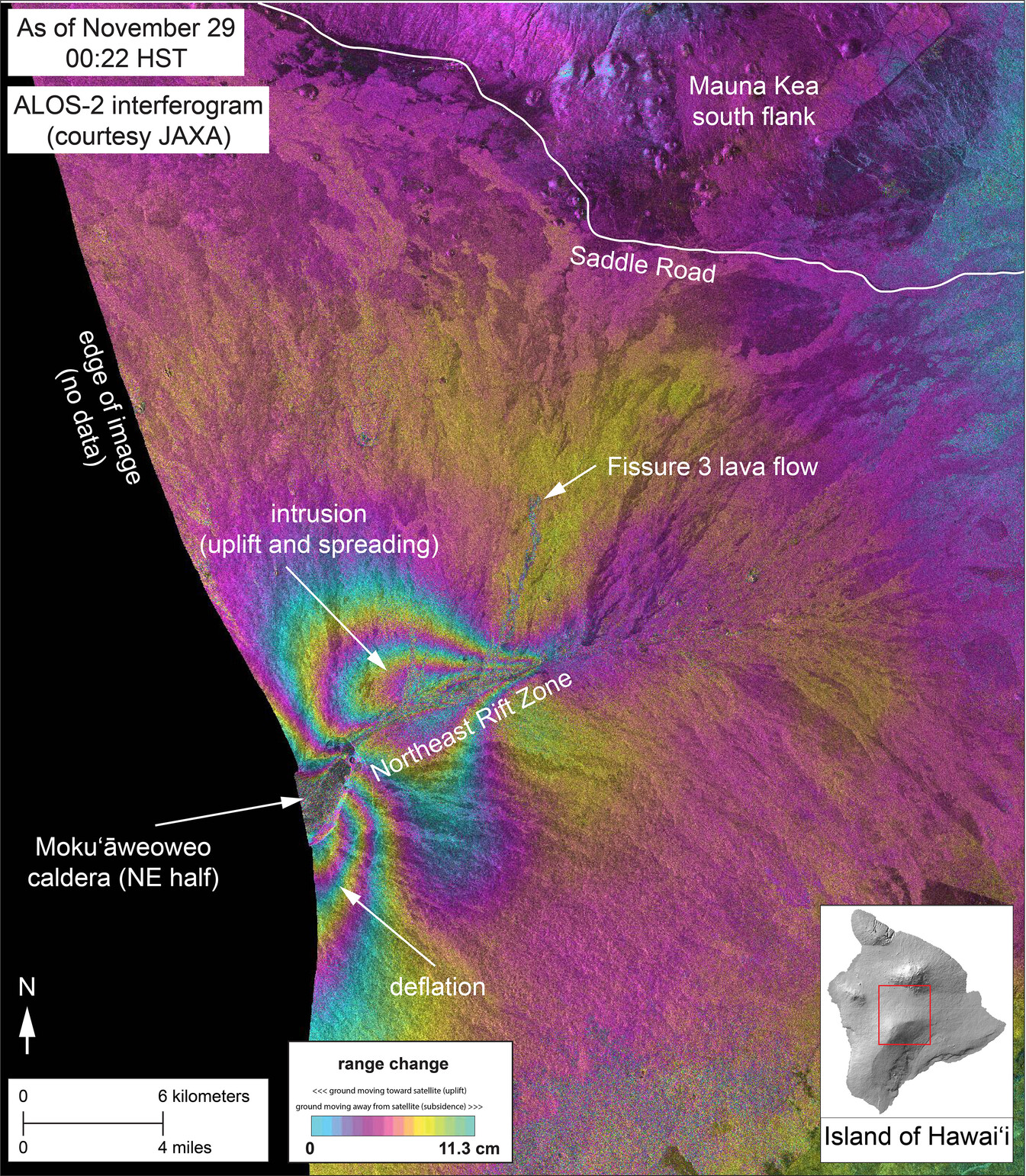
#Radar #interferogram showing deformation of Mauna Loa through Nov. 29 at 00:22 HST. Article on how to interpret this image is at http://ow.ly/a9wv50LROXU
Jason R. Patton
boosted
A list of frequently asked questions about the current #Taupō unrest:
https://www.geonet.org.nz/news/2U5QAOkpT3OAkStjNlngNu
#NZTwits #volcano #NewZealand #Aotearoa
- eq Reports
- https://earthjay.com
lover of mud, sand, gravel, chocolate and Earthquake Reports at https://earthjay.com
Joined Nov 2022
