

Jason R. Patton @earthjay@qoto.org
- eq Reports
- https://earthjay.com
lover of mud, sand, gravel, chocolate and Earthquake Reports at https://earthjay.com
Joined Nov 2022
#EarthquakeReport for M5.9 #Lindol #Earthquake in #Mindanao #Philippines
shallow crustal
strike-slip
probably left-lateral along the Philippines fault system
https://earthquake.usgs.gov/earthquakes/eventpage/us6000lgpg/executive
tectonic background & historical analogues
https://earthjay.com/?p=5255
#EarthquakeReport for M5.9 #Lindol #Earthquake in #Mindanao #Philippines
intensity report MMI5
crustal strike-slip
probably along Philippine fault system http://dx.doi.org/10.5772/56593
https://earthquake.usgs.gov/earthquakes/eventpage/us6000lgpg/executive
tectonic background & historical analogues
https://earthjay.com/?p=5255
#EarthquakeReport for #OTD in 1989 M6.9 #Earthquake in central #California
#LomaPrieta #WorldSeries temblor occurred along the #SanAndreas fault system
landslides & liquefaction
strong & widely felt ground shaking
many casualties :-(
extensive report:
https://earthjay.com/?p=8992
#EarthquakeReport for M4.8 #Earthquake near #Petrolia #california
left-lateral strike-slip (?) earthquake within the Gorda plate
https://earthquake.usgs.gov/earthquakes/eventpage/nc73947830/executive
read about regional tectonics here: https://earthjay.com/?p=10604
@ingalls yes, it could be in the top, but i suspect that, if in the jdf plate, it might be in the lower part because the plate is starting to bend here (causing extension in upper part and compression in lower part).
after i posted this, the depth got closer to the megathrust interface depth, so i began to think that this may be on the megathrust itself.
#EarthquakeReport for #OTD in 2016 M6.4 #Earthquake offshore of #NewBritain #PapuaNewGunea
intermediate depth normal (extensional) earthquake within (intraslab) the Solomon Sea plate
read more:
https://earthjay.com/?p=4346
In Memoriam: James Frazier “Jim” Davis (1931–2023)
California Geological Survey, California State Geologist, 1978–2003
https://www.conservation.ca.gov/cgs/pages/tributes/jim_davis.aspx
#EarthquakeReport for #OTD in 2018 M7.0 #Earthquake in #NewBritain #PapuaNewGuinea
reverse (compressional) earthquake mechanism
learn more here:
https://earthjay.com/?p=7839
#EarthquakeReport for M 4.5 #Earthquake beneath #Washington
Shaking intensity up to MMI 5
Compressional earthquake mechanism suggests the event may be in North America plate
Learn more about the Cascadia subduction zone here: earthjay.com/?p=3640
#EarthquakeReport for M 4.5 #Earthquake beneath #Washington
Depth suggests may be intraplate earthquake, within subducted Juan de Fuca plate (?)
Learn more about the Cascadia subduction zone here: https://earthjay.com/?p=3640
https://earthquake.usgs.gov/earthquakes/eventpage/uw61965081/executive
#EarthquakeReport for M 6.7 & M 6.9 #Earthquake sequence in and offshore of #PapuaNewGuinea
two reverse (compressional) intraplate (?) earthquakes
earthquakes appear to reveal geometry of subducted slab (?)
low intensity ground shaking
read report here https://earthjay.com/?p=11470
Jason R. Patton
boosted

#EarthquakeReport #TsunamiReport for #OTD M 7.5 #Gempa #Earthquake in #Dongalla #Palu #Sulawesi #Indonesia
left-lateral strike-slip earthquake
kilometer scale ground failures
large tsunami runups
reports:
https://earthjay.com/?p=7793
https://earthjay.com/?p=7866
#EarthquakeReport for M5.4 #Gempa #Earthquake offshore of #Sumatra #Indonesia
Possibly aftershock from 2012 Wharton Basin M8.6 earthquake sequence
Read about 2012 earthquakes earthjay.com/?p=294
https://earthquake.usgs.gov/earthquakes/eventpage/us6000lb60/executive
#EarthquakeReport for #OTD in 2016 M 4.9 #Earthquake offshore of #Oregon #California
classic left-lateral strike-slip earthquake along reactivated faults within the Gorda plate
read more: https://earthjay.com/?p=4320
Jason R. Patton
boosted

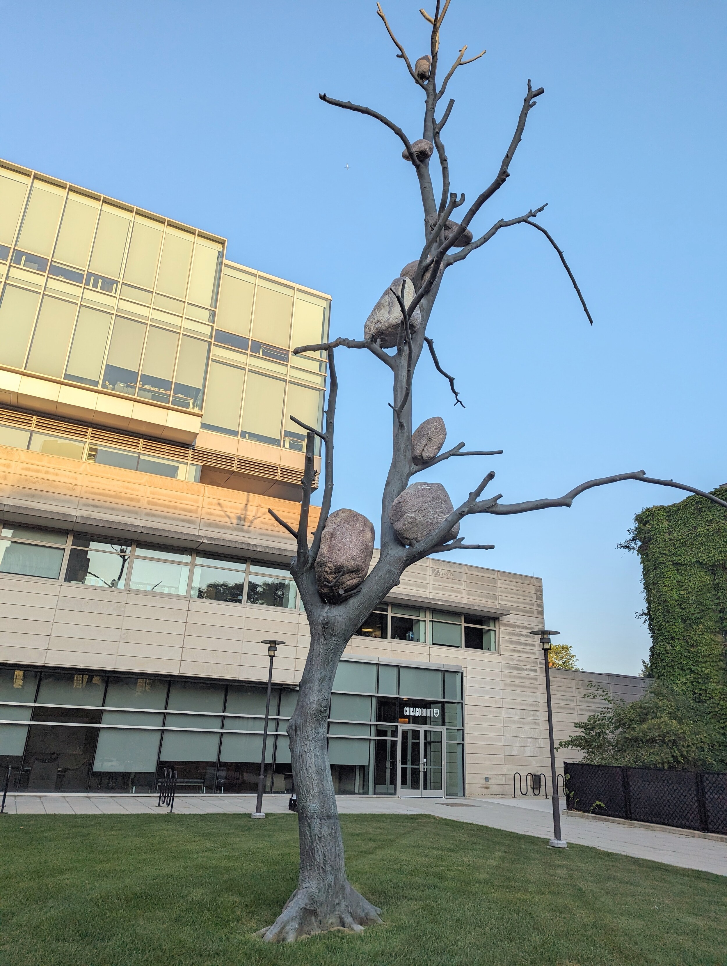
I'm a geologist and this isn't cute or funny. Rocks only climb trees like this when they're very stressed.
#EartthquakeReport #EarthquakeToot #TsunamiReport for M7.2 #Earthquake & #Tsunami offshore of #Alaska
megathrust interface eq in area of low slip '20 M 7.8
tsunami at Sand Point
read more about '20 (in green) '21 (blue) sequences in '21 report https://earthjay.com/?p=9849
https://earthquake.usgs.gov/earthquakes/eventpage/us7000kg30/executive
Jason R. Patton
boosted

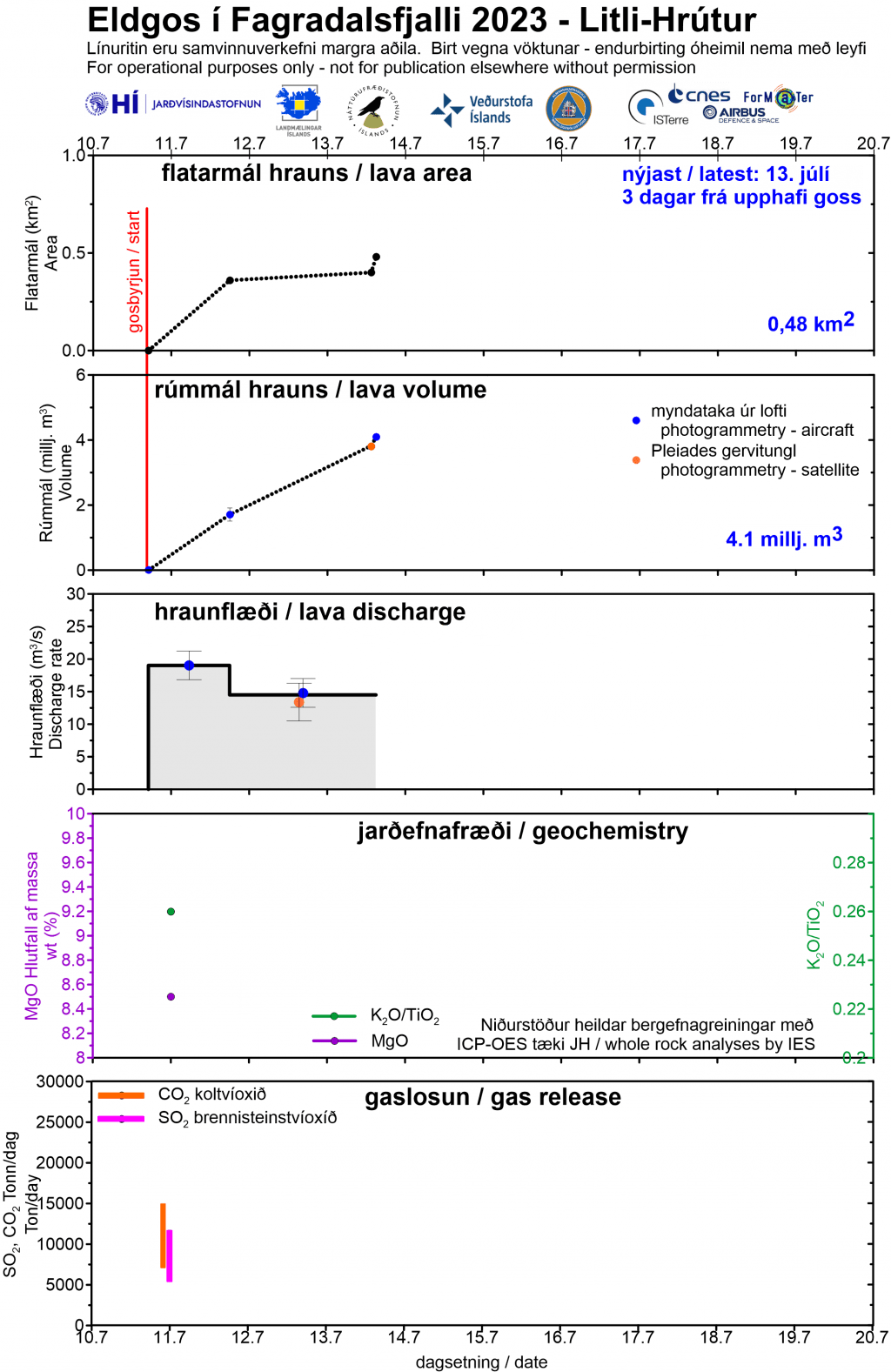
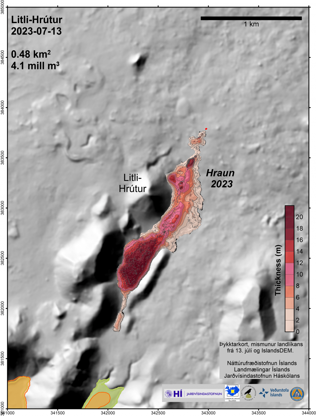
Data from #LitliHrutur eruption as of July 13 by #Iceland Institute of Earth Sciences - graph in Icelandic & English; maps in Icelandic - "hraun" is Icelandic for lava and marks lava flows from 2021, 2022 & 2023. https://jardvis.hi.is/is/eldgos-vid-litla-hrut-nidurstodur-maelinga-13-juli #Fagradalsfjall #volcano🌋 #geology
- eq Reports
- https://earthjay.com
lover of mud, sand, gravel, chocolate and Earthquake Reports at https://earthjay.com
Joined Nov 2022
