

Jason R. Patton @earthjay@qoto.org
- eq Reports
- https://earthjay.com
lover of mud, sand, gravel, chocolate and Earthquake Reports at https://earthjay.com
Joined Nov 2022
#EarthquakeReport for M7.3 #Sismo #Terremoto #Earthquake en #Chile #Bolivia
this shows the @USGS_Quakes estimate of fatalities & damage
hopefully not too many fatalities!
learn more about regional tectonics: https://earthjay.com/?p=8588
https://earthquake.usgs.gov/earthquakes/eventpage/us7000n05d/executive
#EarthquakeReport for M7.3 #Sismo #Terremoto #Earthquake en #Chile #Bolivia
intermediate depth
normal (extensional) mechanism
"slab" event within subducted Nazca plate
chance for liquefaction
learn more about regional tectonics: https://earthjay.com/?p=8588
https://earthquake.usgs.gov/earthquakes/eventpage/us7000n05d/executive
Jason R. Patton
boosted

Very pleased to have been involved in this study, published today in a First Release version, which shows that the earliest large Antarctic Ice Sheet that developed about 33.7 million years ago did not extend to West Antarctica.
1/9
https://www.science.org/doi/10.1126/science.adj3931
Jason R. Patton
boosted
Explainer article about new paper about the dawn of Antarctic ice sheets. First Release version of paper published today in Science.
https://www.bas.ac.uk/media-post/the-dawn-of-the-antarctic-ice-sheets/
#EarthquakeReport for M5.7 #Earthquake offshore #VancouverIsland #Canada
Probably strike-slip (?) Maybe normal (extensional) (?)
Sequence of earthquakes where these are common
Learn more from 2018 report:
https://earthjay.com/?p=7888
https://earthquake.usgs.gov/earthquakes/eventpage/us7000mx3m/executive
#EarthquakeReport for #OTD in 2019 the #Ridgecrest #Earthquake Sequence in southern #California
M6.4 left-lateral strike-slip earthquake triggered M7.1 right-lateral ss eq
generated liquefaction/landslides
@CAGeoSurvey @USGS_Quakes responded
read reports https://earthjay.com/?p=8656
#EarthquakeReport for M7.2 #Sismo #Terremoto #Earthquake en #Peru
megathrust subduction zone earthquake (?)
#Tsunami observed at Arequipa tide gage near epicenter
40cm wave height
20cm amplitude
Regional tectonics in 2021 report:
https://earthjay.com/?p=9916
https://earthquake.usgs.gov/earthquakes/eventpage/us6000n8tq/executive
#EarthquakeReport for M7.2 #Sismo #Terremoto #Earthquake en #Peru
High shaking intensity
Reverse (Compressional) earthquake mechanism
Appears to be megathrust subduction zone earthquake
Regional tectonics in 2021 report:
https://earthjay.com/?p=9916
https://earthquake.usgs.gov/earthquakes/eventpage/us6000n8tq/executive
#EarthquakeReport for M4.5 #Earthquake in the #Geysers region of northern #California
the Geysers is an active geothermal area
map shows 30 days of earthquakes
>1300 events
https://earthquake.usgs.gov/earthquakes/eventpage/nc75017972/executive
regional tectonics in 2017 report: https://earthjay.com/?p=6593
#EarthquakeReport for M4.5 #Earthquake in the #Geysers region of northern #California
right-lateral (?) strike-slip earthquake
the Geysers is an active geothermal area
intensity MMI 6
https://earthquake.usgs.gov/earthquakes/eventpage/nc75017972/executive
regional tectonics in 2017 report: https://earthjay.com/?p=6593
Jason R. Patton
boosted

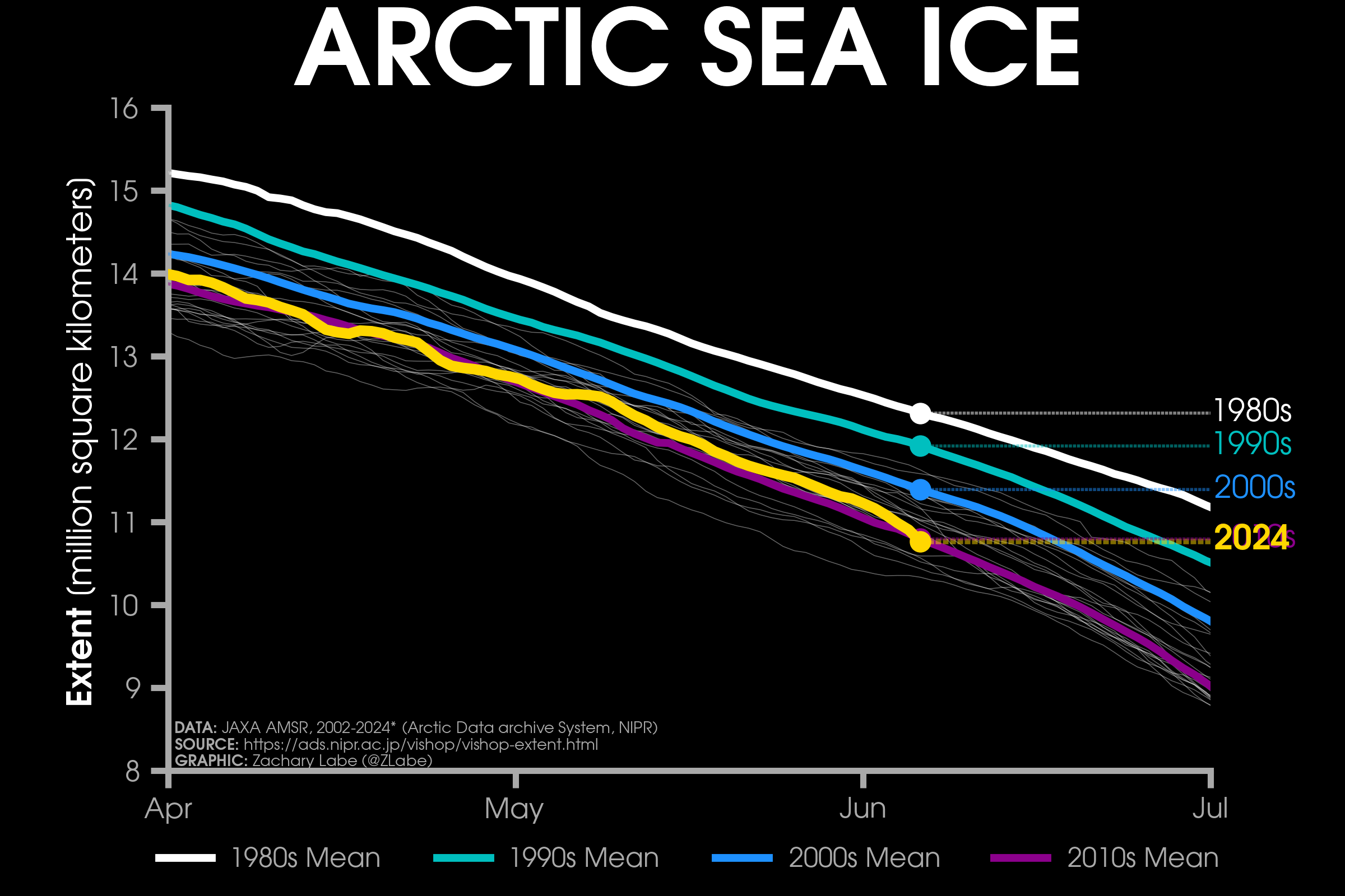
Have a great weekend! Here's your Friday ice update - #Arctic sea ice extent is currently the 6th lowest on record (JAXA data)...
• about 30,000 km² below the 2010s mean
• about 630,000 km² below the 2000s mean
• about 1,150,000 km² below the 1990s mean
• about 1,550,000 km² below the 1980s mean
More plots: https://zacklabe.com/arctic-sea-ice-extentconcentration/
#EarthquakeReport for shallow M 4.2 #Earthquake offshore of northern #California #HumboldtCounty
left-lateral (?) strike-slip (side-by-side) mechanism
probably in Gorda plate
https://earthquake.usgs.gov/earthquakes/eventpage/nc75017417/executive
learn more about regional tectonics: https://earthjay.com/?p=10604
#EarthquakeReport for #Earthquake along the Tonga plate boundary
reverse or thrust (compressional) mechanism
intermediate depth
event within subducted Pacific plate
https://earthquake.usgs.gov/earthquakes/eventpage/us6000n158/executive
learn about regional tectonics in 2022 report:
https://earthjay.com/?p=10493
#EarthquakeReport for #OTD in 2019 M 8.0 #Sismo #Terremoto #Eartthquake in #Peru
intermediate depth yet widely felt
@USGS_Quakes models suggest chance for triggered landslides and induced liquefaction
learn more:
https://earthjay.com/?p=8541
#EarthquakeReport for M4.9 #Sismo #Terremoto #Earthquake en #Mexico
Normal (extension) earthquake mechanism
Learn about the southern Pacific-North America plate boundary in 2018 report
https://earthjay.com/?p=6962
https://earthquake.usgs.gov/earthquakes/eventpage/ci40746912/executive
#EarthquakeReport #EruptionReport for #OTD in 2018 M6.9 #Earthquake in #Hawaii
part of #Kïlauea #Volcano eruption event
generated #Tsunami
@USGS_Quakes models show chance of earthquake triggered #Landslides
learn more https://earthjay.com/?p=7350
#EarthquakeReport for #OTD in 2020 M6.5 #Earthquake offshore of #Crete
reported shaking intensity MMI5
generated #Tsunami
learn more https://earthjay.com/?p=9493
#EarthquakeReport for #OTD in 2017 M6.2 & M6.3 #Earthquake couplet in #BritishColumbia
right-lateral strike-slip (side by side motion, like the San Andreas fault) earthquake associated with the Denali/Chatham Strait fault system
learn more https://earthjay.com/?p=5345
#EarthquakeReport for #OTD in 1992 M7.2 Cape Mendocino #Earthquake in #Humboldt County #California
take a mythical journey with a student following the earthquake as they made discoveries https://storymaps.arcgis.com/stories/695f0487e6764718bb36ca05d1bb7404
learn from @CalConservation @CAGeoSurvey https://www.conservation.ca.gov/cgs/earthquakes/cape-mendocino
#EarthquakeReport for #OTD in 1992 M7.2 #Earthquake in #HumboldtCounty #California
I was there
triggered 2 M6+ eqs
generated tsunami, led to the National Tsunami Hazard Mitigation Program
landslides and liquefaction
learn more: https://earthjay.com/?p=5233
& https://earthquake.cascadiageo.org/?page_id=130
- eq Reports
- https://earthjay.com
lover of mud, sand, gravel, chocolate and Earthquake Reports at https://earthjay.com
Joined Nov 2022
