

Jonathan Hunter @chattwjonathan@qoto.org
Meteorologist, Trucking Industry, Accident Investigation, Chattanooga FC fan, Tennessee Based, Husband, Father of 2
Joined Nov 2022
Jonathan Hunter
boosted

I'm last author of this recently published paper on the Quaternary #tectonics and uplift of the Kythira island (#Aegean sea and Hellenic Arc) by Gino De Gelder et al., in AGU Tectonics.
#openaccess https://doi.org/10.1029/2022TC007231
Jonathan Hunter
boosted

Good morning east of the Rockies in Colorado and New Mexico. Snow is on the road on I-25 in southern CO this AM, and moving east and south through Western KS, the Oklahoma Panhandle and the Texas Panhandle.
3-6" of snow expected on I-40 in W. Oklahoma, as this cold front meets more saturated air and spins up a more intense low (a 'Panhandle hooker'). More modest snowfall expected elsewhere.
WSSI showing a moderate impact expected and outlines I-35 south of OKC as well. Going to see the system split somewhat with NW Arkansas hit with one lobe and Kansas City and norther MIssouri taking the other.
Expect additional advisories potentially expanding at the 3pm updates - and new issued for Pennsylvania/upstate New York for tomorrow.
Jonathan Hunter
boosted

#EarthquakeReport #EarthquakeToot for #OTD in 2019
M7.1 #Gempa #Lindol #Earthquake offshore of #Halmahera #Indonesia
fascinating subduction dipping both east & west
generated modest #tsunami
read more: regional tectonics, seismic hazard/risk
https://earthjay.com/?p=9106
Jonathan Hunter
boosted

I spent a lot of time this summer photographing and studying the incredible Osprey. Some of my favorite moments were sitting on the bank of the Tennessee River at either Nickajack or Chickamauga Dams and watching as these incredible hunters fed their families.
This collection highlights a few of the more interesting things about these beautiful birds.
1. Ospreys spend an incredible amount of time flying, their hunting process usually involves circling over a body of water until they spot a fish, at which point they switch into a back stroke and hover momentarily plotting the fishes course and where their strike should be, they then transfer into a dive that usually results in a bad day for the fish.
2. I'm amazed at just how much weight these birds can carry, though I did observe a few times a smaller bird having to give up and drop a catch, only to have a larger, stronger bird swoop in and collect the kill.
3. Just before they hit the water, these birds have a third eyelid, called a nictating membrane that closes to protect their eyes, they often fully submerge in order to collect their prey.
4. Because they hit the water so hard, and often go under the surface, one of their first orders of business is getting rid of the excess weight of the water after a catch. This process involves flying up to about between 2 and 5 meters and then pausing flying to shake, they often take this zero gravity moment to reposition their talons on the fish and orient to the flight direction if they didn't get the perfect grip during their strike.
Jonathan Hunter
boosted

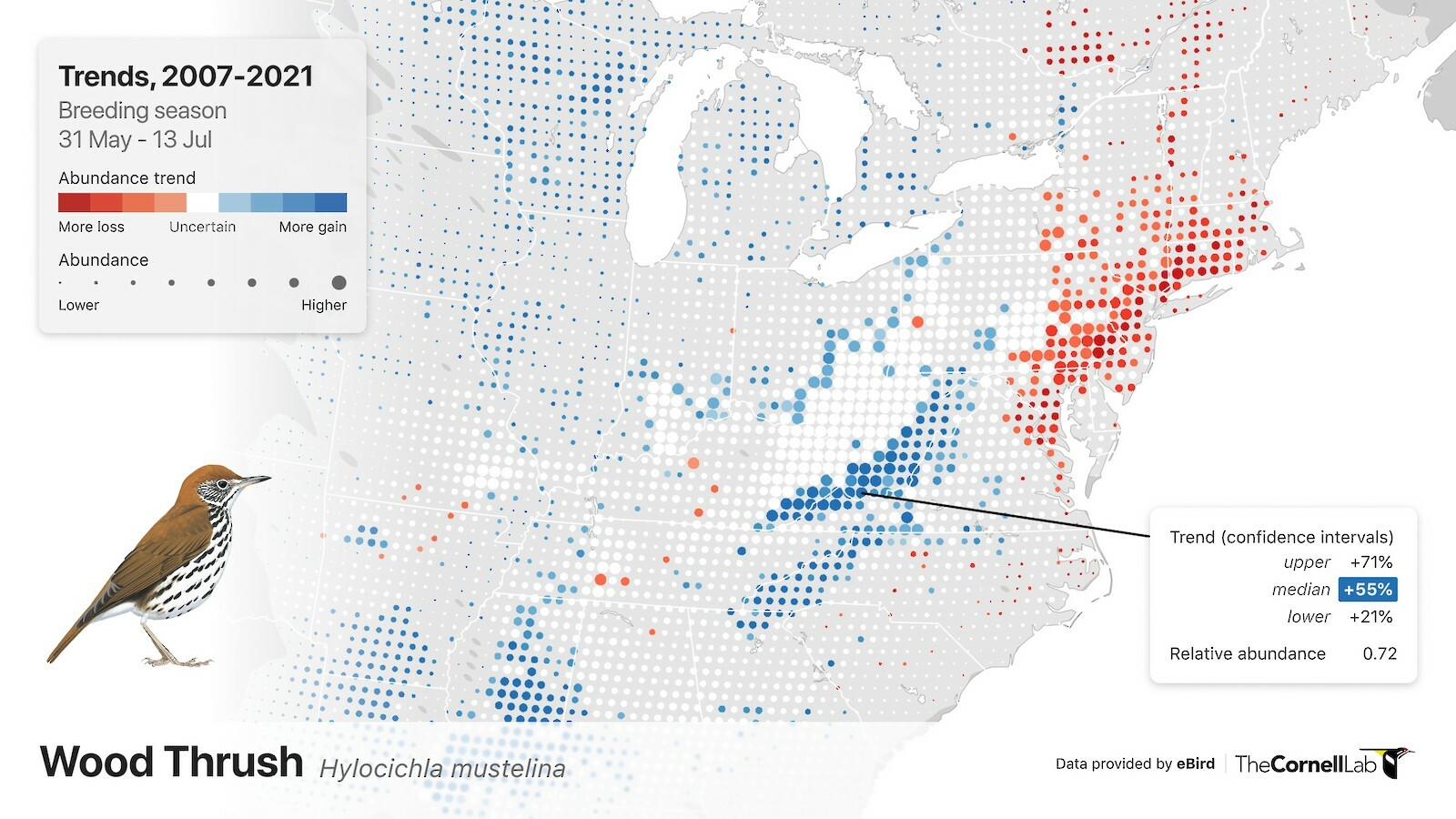
This week the Cornell Lab of Ornithology released fine scale population trends maps for over 500 North American #birds based on #eBird data. These maps are the culmination of several years of research and development by the #eBird Status and Trends team, and all this work was only possible because of the amazing community of eBirders who contributed 43.8 million checklists to the dataset we used to estimate population trends.
Learn more and view the interactive maps at https://science.ebird.org/en/status-and-trends/trends-maps
Jonathan Hunter
boosted

Six weeks ago I first mentioned the potential of a “Falaise Gap” type encirclement in Kherson on @CNN with the potential of the capture of 10-25,000 Russian soldiers. Ukraine reports indicate a rout close to the scale of that is happening.
If RU did not prepare for this & thousands of soldiers are killed/captured, it cements the known incompetence of the RU Army. If soldiers are captured, Ukraine MUST treat them under Geneva convention rules.
Jonathan Hunter
boosted

Tonight's national weather radar is full of activity. What's left of #HurricaneNicole is spinning in the southeast; rain along the cold front from Wisconsin to Oklahoma; heavy snow in North Dakota and Minnesota. And the appearance of nighttime bugs, bats, and other flyers across the southeast, too!
Here are some of the basic implications of Potential Temperature ( θ ):
Space close to Earth is extremely hot despite the temperature
The core of the earth and any other planet is extremely cold despite the temperature.
These are typically opposite of intuitive concepts, but are true nonetheless.
We can observe Potential Temperature ( θ ) in nature.
From hiking in the mountains, we know that it's cooler when we go up. Snow falls on the tops of the mountains first. Etc.
But we also know that warm air should generally rise because it's less dense.
And this is where Potential Temperature comes in. If you were to bring that mountain air down to the surface pressure, it would expand, the added pressure on it would warm it. The mountain air would be WARMER than the other air at the surface.
Thus the atmosphere is stacked how you believe it should be. With less dense ( higher potential temp) air on top of more dense ( lower potential temp) air.
Potential temperature and temperature surfaces are two topics that just blow my mind in meteorology.
Potential temperature is the actual temperature of air or water standardized to a constant pressure. And in meteorology that pressure implies height.
Meteorologist, Trucking Industry, Accident Investigation, Chattanooga FC fan, Tennessee Based, Husband, Father of 2
Joined Nov 2022
